 |
| Jim Woodmencey, meteorologist |
Temperatures will be warming up pretty significantly around the Western US the rest of this week and into early next week (June 5 to 11) not just at the lower elevations but also up at higher elevations, were there is still significant snow to melt above about the 9,000-ft. elevation.
At around 10,000-ft. this week in the Tetons, for example, temps will get into then 60’s during the day and not re-freeze overnight, only dropping into the 40’s for overnight lows. This will lead to melting occurring 24-hours a day for several days in a row.
Settled Snowdepths on Wednesday June 5, 2013
Rendezvous Bowl (Elevation 9580-ft.) = 44 inches
Targhee Snotel (Elevation 9260-ft.) = 61 inches
Snowpacks should be shrinking pretty significantly as we go into next week. And expect rising creeks and rivers from the runoff, the peak of that should be seen about the third day into the meltdown.
|
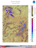
Snow Depth Map
|
Snow Water Map
|
River & Reservoir Levels
|
|
|
|
|
This is a big change from the last couple of weeks of relatively cool temps, below freezing at 10,000-ft. most nights and highs generally in the 40’s most days. And there were even a few days when we had snow accumulating above 9,000-ft. in the mountains.
Post by Jim Woodmencey, meteorologist
Graphics from NOAA & BOR


