 |
| Meteorologist Jim Woodmencey |
Seasons are definitely changing this week, with word of a “big storm” heading our way, which began its hype on Monday. Sometimes the mere mention of the word “snow” in the forecast will set off a 4-alarm warning, among skiers especially, even in September!
This will actually be the second storm this September to bring snow to the Tetons. The first one was on September 18th, and most of that snow has melted off except for a skiff on north faces above 10,000-ft.
This incoming storm will bring even colder air with it and snow levels will get down near the valley floor, probably by Thursday the way it looks right now. It will be selective about where it deposits the bulk of the snow, as the whole weather system divides as it crosses the Rockies.
Best moisture comes over western Wyoming when snow levels are still fairly high during the day on Wednesday.
Certain areas in Western Wyoming will be favored as this large Low pressure Trof appears to split up as it moves across the Rockies, with the main center of that Low going north into Montana and eventually Southern Canada by the end of the week. And the southern part swinging across Nevada & Utah and eventually Colorado.
The higher elevations of Yellowstone Park (especially the SW corner of the Park) and the Wind River Range will potentially receive the most snowfall. As snow levels lower progressively Wednesday thru Thursday in western Wyoming, the lower elevations pick up some snow, as well. I also expect the Tetons will see a brief period of enhanced snowfall when that Low is over us and moving across Southwest Montana.
Who Gets It?
This is also a good looking set-up for Central Idaho’s Mountains, as they get into the colder air sooner, when the storm is still intact as it moves inland Tuesday night/Wednesday. And then another swath of snow will be likely across Southwest and Central Montana, initially with a SW flow as the Low approaches for west of the Divide, and then east of the Divide (central Montana) with decent upslope flow once the Low moves into eastern Montana.
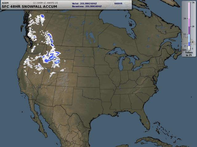
A variety of different computer models depict the variability of the snowfall accumulation & distribution across the Northwestern US and NW Wyoming with this storm, and a few of those are shown below for comparison. Note that they each cover a different time period. So, which one is correct?
(Hint: A skier will pick the one that shows the greatest amount of snow where they like to go, every time!)
Don’t pull on your snow pants just yet, it will warm up over the weekend and melt a good portion of what accumulates in the mountains this week.
 |
| NAM 48-hour Total Snow Accumulation Tues. a.m thru Wed. p.m. |
 |
| MFF Total Snow Accumulation Tues. a.m. thru Fri. a.m. |
 |
| WRF Total Snow Accumulation Tues. a.m. thru Thursday evening. |
 |
| Same Map as Above (WRF) zoomed in on Western Wyoming |
Post by meteorologist Jim Woodmencey
Graphics courtesy of LEADS On-Line
and USDA-FS Fireweather

