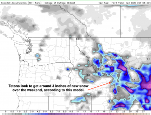
Winter Weather comes to Wyoming this weekend. With a relatively large and cold Low pressure system moving into the Rockies on Saturday, then hanging out over the Central Rockies Sunday into Monday. This will create an “upslope” flow pattern against the Continental Divide.

Initially, the Tetons will pick up a little new snowfall, as that weather system approaches from the West, perhaps a total of 4 to 6 inches at higher elevations, which is more than the models depicted below are forecasting.

Looks like the Wyoming Range, south of the Jackson Hole area will do best on the West side of the Divide, maybe picking up a foot of new snow.

Mountain Ranges along and East of the Continental Divide, the Wind River Range and Absaroka Mountains could see a foot or so of snow at higher elevations through Monday morning.
Posted by meteorologist Jim Woodmencey

