 |
| Meteorologist Jim Woodmencey |
The storm from this past weekend brought snow, along with a lot of wind to the Jackson Hole area. Around two feet of snow to the higher elevations of the Tetons, containing over 2 inches of water snow from Friday night thru Monday morning. Winds were averaging around 30 mph at ridgetop level, with gusts over 60mph, helping to load leeward slopes and creating dangerous avalanche conditions.
With all the wind we had, it is difficult to get a completely accurate reading of snow or water amounts. It’s hard to chase that snow down when it is falling horizontally!
The Bridger-Teton National Forest Avalanche Center reported on Monday morning that some areas at the higher elevations received as much as 45 inches of snow over the past 4 days, along with 4.5 inches of water.
A summary of data reported during this past week’s storm cycle, taken from the Rendezvous Bowl and Raymer weather plots located at around 9500-ft. at JHMR, is shown in the table below. Almost 3 feet with more than 3 inches of water!
|
Summary of Snow and Water Accumulation
24-Hour and Storm Totals |
||||
|
Date
|
Rendezvous Bowl
|
Raymer
|
||
|
Snow (in.)
|
H2O (in.)
|
Snow (in.)
|
H2O (in.)
|
|
|
Thursday, Jan. 9
|
13
|
1.10
|
10
|
.90
|
|
Friday, Jan. 10
|
4
|
.35
|
3
|
.27
|
|
Saturday, Jan. 11
|
7
|
.70
|
12
|
.80
|
|
Sunday Jan. 12
|
10
|
1.20
|
9
|
1.10
|
|
4-Day Storm Totals:
|
34”
|
3.35”
|
34”
|
3.07”
|
|
Data from BTNF morning weather summaries of preliminary data from these stations.
|
||||
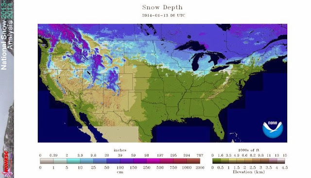
USA Snow Depths
For many parts of the west, especially the Sierras, it has been a slim snow year, so far. However, parts of West are doing just fine. The North Cascades, Central Idaho mountains, western Montana’s mountains, the mountains of NW Wyoming, and the higher elevations of the north-central Colorado Rockies have some of the deepest snowdepths in the United States as of Monday morning, January 13, 2014. (See maps below).
 |
| USA Snowdepths as of January 13, 2014 |
 |
| Zoom on Western US Snowdepths |
Post by Meteorologist Jim Woodmencey
Data from BTNF
Graphic from NOAA

