 |
| Meteorologist Jim Woodmencey |
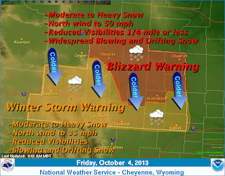
Pretty good snowstorm for the western Wyoming mountains Thursday/Thursday night. But a really good snowstorm for the rest of Wyoming for Friday & Friday night. Winter Storm Warnings and Blizzard Warnings issued for much of the eastern half of Wyoming.
Some snow for the Colorado Rockies with this storm, but the Plains of Nebraska and South Dakota really get hammered by this weather system as it moves east Saturday.
|
|
Snowdepths Getting Deep for Early October
Up in the Teton mountains there is now a foot or more of snow up around the 9,000 to 10,000-ft elevation being reported on the few instruments that are up and running. For instance, the Snotel sensor at Grand Targhee at an elevation of 9260-ft. is showing a 13 inch snow depth.
The Snotel sensor on Togwotee Pass at the 9850-ft. elevation is showing 16 inches of settled snow depth at 8:00 a.m. on Friday, October 4th.
Over in the Wind River Range, which stands to get the most snow from this storm as it is now more of an “upslope” event for areas along and east of the Continental Divide (as the Low pressure center moves into Central/Eastern Wyoming), there dis even more snow on the ground now. Hobbs Park Snotel is at 10,100-ft., along the eastern side of the Winds, and it shows a 20 inch sow depth this morning.
Oh, and by the way, the temperature up at around the 10,000-ft. elevation this morning is 18 degrees. I guess we are skipping Fall and heading right into Winter.
|
|
Keep track of Jackson Hole & Wyoming Weather & Snowfall
If you want a quick way to check out all the local weather instruments, go to the “WAM” (Weather Access Map) for the Jackson Hole & Yellowstone area…..click here: WAM Tetons
There is also a “WAM” for the State of Wyoming……click here: WAM Wyoming
Both of thees maps will get you to the latest data and also the latest forecasts for those same locations.
(Note: Utah & Colorado WAM’s will be available soon, hopefully soon enough!)
Post by meteorologist Jim Woodmencey
Maps courtesy of the NWS


