 |
| Meteorologist Jim Woodmencey |
The First Day of the Fall Season doesn’t get here until Sunday, September 22nd, but we will see a change in the weather pattern from what has been relatively warm to relatively cooler beginning Wednesday.
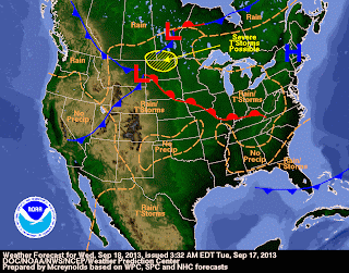
There will be a series of storm systems of different sizes and shapes working out of the Gulf of Alaska and moving across the Northwestern US over the course of the next 7 to 10 days, and each of these will be cold enough for some white stuff in the higher elevations, at least above 10,000-ft.
The first Low pressure system moves thru Tuesday night and early Wednesday. Then a break in the weather and warming Thursday & Friday. Next weather system looks weak but may bring some showers to the mountains later Saturday and on Sunday. Then another break between weather systems Monday & Tuesday of next week, with a larger and even colder looking Low pressure system moving into the Western US Thursday and Friday of next week, with snow levels may be down even lower.
Not to the valley floor, and not huge amounts of snow up high, but enough for a reminder that it ain’t summer anymore.
We also could see below freezing temps in the Jackson Hole valley this week, especially Friday morning with clearer skis overnight Thursday.
|
|
Freeze-free Days in Jackson
With high temperatures still reaching into the 70’s this week (78 in town on Monday!) and lows only in the 40’s most mornings, it may seem like we have had a long “frost-free” season this summer. But actually it was probably not as long as you might think.
According to the thermometers at the Jackson Climate Station the last day below freezing overnight low temps in the Spring was on June 23rd (28 degrees). And the next time it got below freezing was on September 1st ( 30 degrees). That’s 69 days, by my math, of “frost-free” or “freeze-free” days.
Although, there was one day in mid-August that it got down to 32 degrees for a morning low……if that qualifies as a “freezing” day, then our growing season was split in two!
Post by meteorologist Jim Woodmencey
Maps from NWS


