 |
| Meteorologist, Jim Woodmencey |
Nearly record HOT in Jackson this weekend with the Town’s automated weather station reporting a high on Sunday of 90 degrees. Record high on June 30th in Jackson is 91 degrees set back in 1990.
FYI…Record high for July 1st is 92 degrees, also set in 1990.
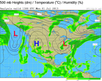
Hot temps are courtesy of a big Ridge of High pressure that is sitting in place over the Western US. About as hot as it can be, for almost any summer month, but especially for late June in the Desert Southwest.
Looks like one or two more days of this before the Ridge breaks down a little and temps cool for the end of the week.
Some of the hottest high temperature records that were re-set this weekend are listed below.
Death Valley, CA…………..…….128 degrees on Saturday (ties highest June temp)*
Death Valley tentatively reached 129 degrees Sunday evening, and that breaks June record high. Which would tie for the hottest temp ever in the month of June in the US, set in Volcano, CA (not a town anymore!) back in June of 1902.
Las Vegas, NV …………117 degrees on Sunday (ties all-time high temp record for Vegas)
Zion National Park, UT…….112 degrees (ties old record for the date in Zion)
Salt Lake City, UT………….103 degrees (ties old record for June 30th from 1979)
*Death Valley still has the distinction of being the hottest place on earth with their world record high temperature of 134 degrees, set 100 years ago, on July 10, 1913.
Weather Pattern Keeping it Hot
The Ridge of High pressure over the Western US is being held in place by two Troughs of Low pressure in the current blocking pattern that has established itself across North America. This Ridge is warm all the way up through the atmosphere. The air within the two troughs is much cooler.
This is a “blocking pattern”, which means it will be hard to change, kind of like a logjam in the river. The very cold trough off the West Coast will try and flatten this Ridge some towards the end of the week. And that will help cool temps, at least across the Pacific Northwest & northern Rockies.
 |
| Upper Level (500mmb) Map showing large Ridge in Western US flanked by two Low pressure Troughs. |

