Finally some warmer temps and a little fresh snow on Thursday. And it looks like more snow will be possible for Jackson Hole over the weekend, especially on Sunday. I like the way things look to be shaping up.
After a long period of High & Dry & Cold in early January, the changes are certainly welcome. Read on for all the rap from this Friday morning’s forecast……..
Weather Discussion from MountainWeather Forecast for Jackson Hole
Friday, January 27, 2013
Friday, January 27, 2013
We have a split jet stream flow over the Western U.S. today, with one segment of that jet to the North & NW of Wyoming, and the other segment to the South & SW.
We are in-between those jets, with weak High pressure over us trapping leftover moisture from yesterday, keeping some stratus cloud / fog layers around the mountains this morning.
 |
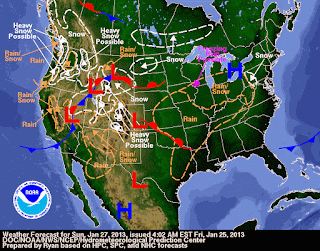
| Weather Map for Sunday January 27, 2013 |
Two Low pressure centers off the Western Coast, one near SE Alaska, which will drop southward over the Pacific Northwest this weekend. And one in the upper levels of the atmosphere off the Southern California Coast.
Those Lows will merge into one larger Trof of Low pressure as they move inland across the Western U.S. this weekend, combining cold air from the northern Low with moist air from the southern Low.
That will produce a moderately strong West to SW flow and also produce some snow around JH. Especially as the jet stream comes together a little better over us on Sunday.
That Trof will take its time crossing the Rockies Monday, bringing much cooler air over us, keeping the atmosphere unstable enough to keep on producing snow showers.
Some drying of the atmosphere Tuesday as we come under more of a Northerly flow. But Wed. thru early Friday it looks like we may get into more of a NW flow, with enough moisture in it to keep some light snow & snow showers going over the mountains.
A Ridge of High pressure over us later Fri. thru Sun. with dry weather next weekend.
Posted by meteorologist Jim Woodmencey
Map from NWS.

