All posts by Jim Woodmencey
Easter Weather Swing
It’s springtime in the Rockies and that means wild weather swings are bound to occur. This week brought high temperatures in the 50’s on Tuesday & Wednesday to Jackson Hole. Then, a perfectly sunny day with no wind on Thursday and temperatures topping 60-degrees in the Town of Jackson.
That nice taste of spring weather all comes to an end this Easter Weekend, as what could be described as an “Alberta Clipper” will drastically change the weather across Wyoming. Satellite image below, from Friday morning April 10, 2020.
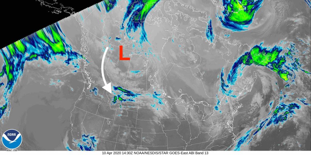
If you want to call it that, this “Clipper” is going to bring colder temps, wind & some snow to Wyoming. Technically, it is an upper level Trof of Low-pressure that will swing down from the north, along the British Columbia & Alberta border. That Trof will then ride along the Continental Divide in Montana & Wyoming before swinging east across northern & central Wyoming on Sunday.
Most of the snowfall this weekend will be east of the Continental Divide.
(See Snowfall Forecast Map below).
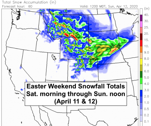
Jackson Hole and western Wyoming will get some rain & snow showers on Saturday, but the real bummer is, we go from being sunny & warm with no wind, to cloudy & colder with windy periods this weekend.
Going from Shorts & T-shirts, back to Pants & Puffy’s.
Post by meteorologist Jim Woodmencey
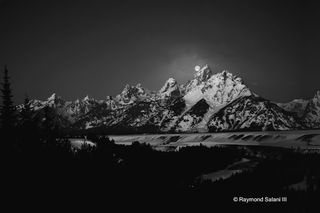
Full Moon Over the Tetons
April Thundersnow
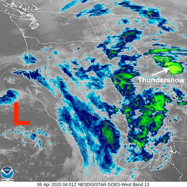
On the night of April 5th, 2020 , moist & unstable air moved over western Wyoming causing thunderstorms and a relatively intense graupel event (round, puffy pellets of snow). In combination, this would be termed a “Thundersnow” event.
Infra-red Satellite image below showing the bright green “cell” that contained those thunderstorms from Sunday night.
Thundersnow is rare and lightning this early in April is not that common. However, in the 38 years I have lived in Jackson Hole, I can say that I have seen lightning every month of the year, including during the depths of the winter season in January & February.
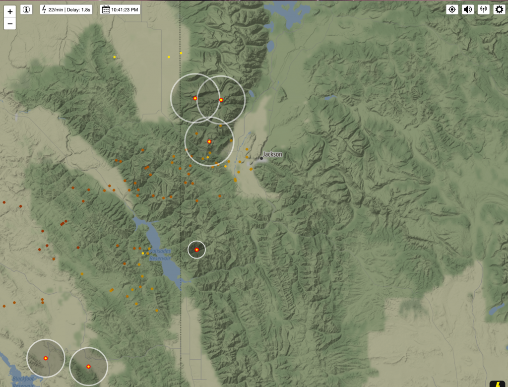
Below is the lightning strike map from 10:41 Pm MDT on Sunday. Yellow dots with red rings the most recent strikes, gold to brown indicates progressively older ground strikes, in the preceding hour or two.
Low-Pressure over California the Cause
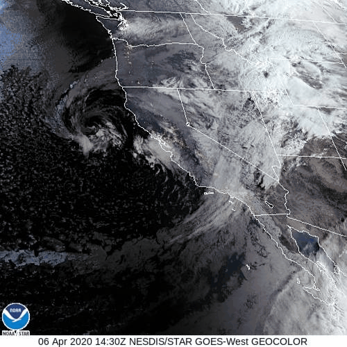
A potent Low-pressure system that is sitting along the central California Coast , which has been bringing heavy rain to the Central Valley of California and heavy snow to the Sierra Nevada mountains, is what was responsible for sending that moist & unstable air over the Inter-mountain West last evening. That air collided with colder, drier air that was in Montana.
Still a little more to come with this storm system Today (Monday) and into Tuesday, as that Low-pressure slowly makes it’s way over southern California. That means, western Wyoming is still in for a mix of rain & snow for the valley, snow in the mountains and the possibility of a few more thunderstorms embedded in all that.
Satellite view below from Monday morning. Low-pressure still spinning around along the California coast.
Snowfall Accumulation Forecast Map below for Monday morning thru Tuesday afternoon. (From CAIC-WRF model)
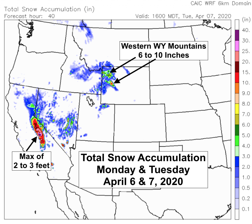
By Wednesday the center of that will be swinging by to the south of Wyoming, across the Four Corners Region and the weather in western Wyoming should improve for Wednesday-Friday.
Post by meteorologist Jim Woodmencey
More Snow, No Foolin
A potent storm system in the Gulf of Alaska will bring snow to the mountains of the Pacific Northwest and Northern Rockies today through Tuesday, lingering into April Fool’s Day.
Map below shows position of Low-pressure Monday, March 30th and forecast position on Tuesday March 31st. Jet stream also pushes inland across Oregon, Idaho and western Wyoming through Tuesday, bringing lots of Pacific moisture in a strong Westerly flow aloft.
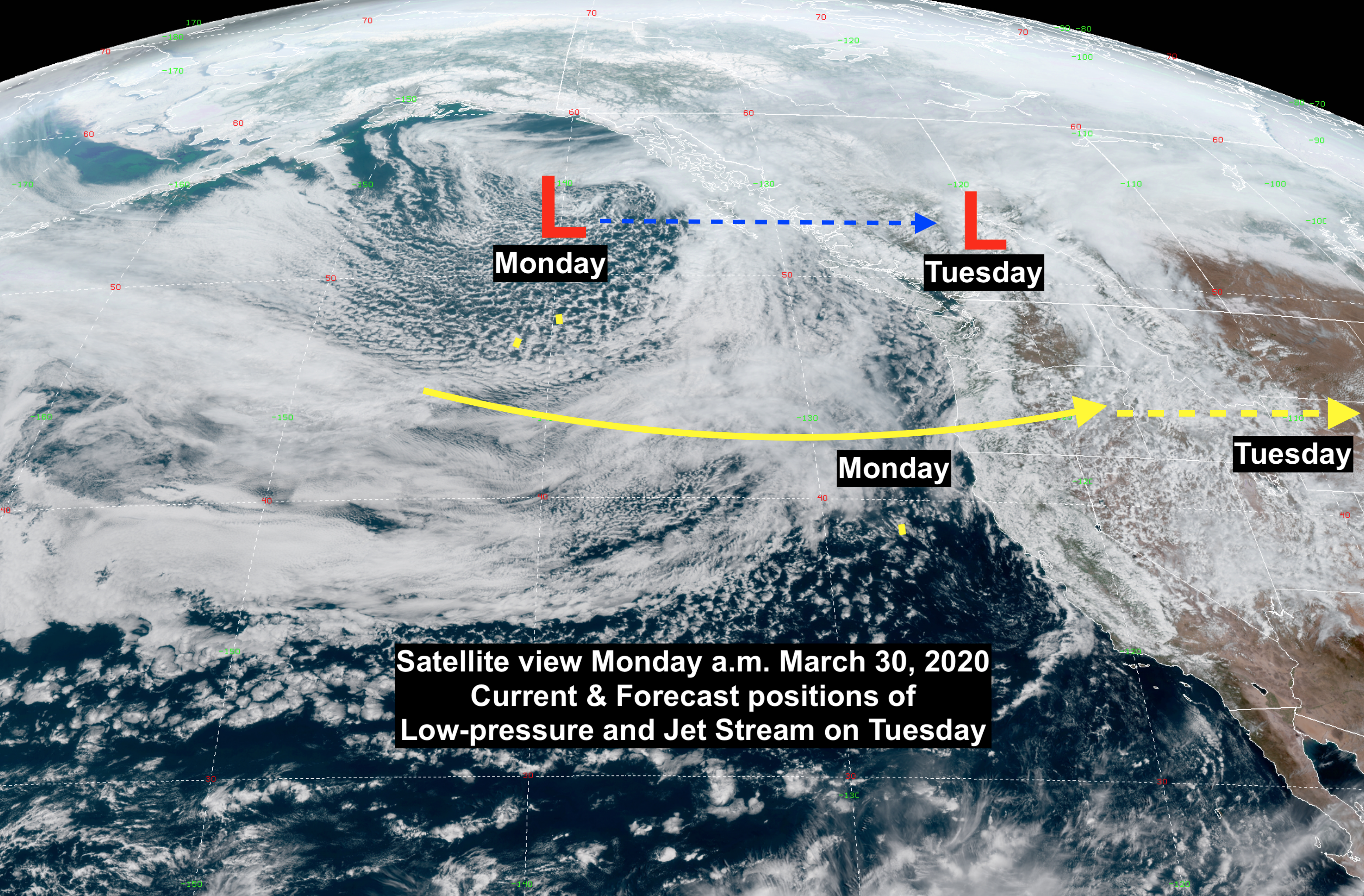
This storm system brings progressively colder air with it, causing snow to progressively lower elevations though Tuesday night. Very unstable atmospheric conditions will also cause some thunderstorms to develop.
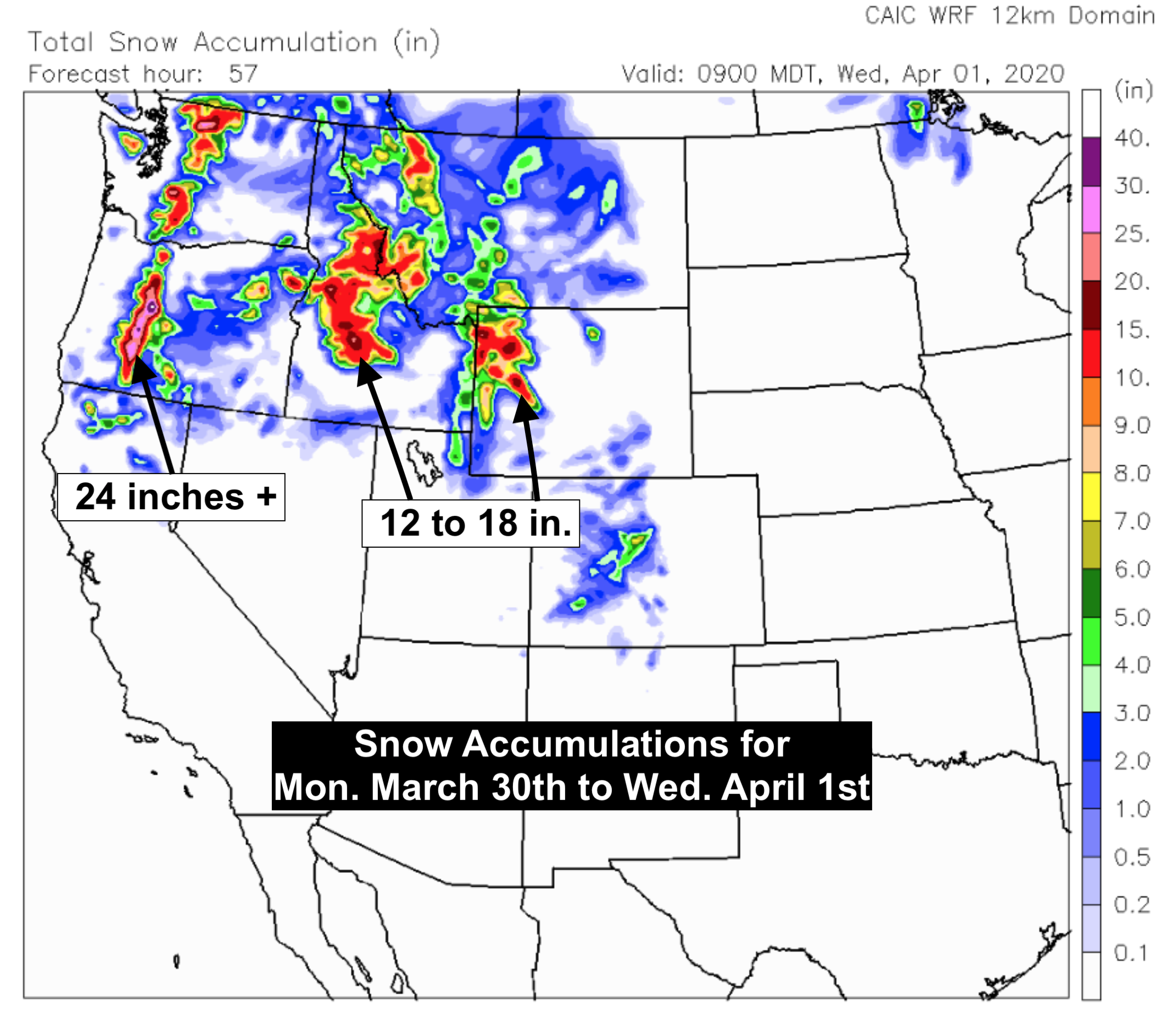
By April Fool’s Day, it looks like snow accumulation in the mountains (especially above @ 9,000-ft.) will be significant: Oregon & Washington Cascades = 24 to 30 inches Central Idaho mountains= 12 to 18 inches. Tetons, Absaroka & Wind River Ranges= 12 to 18 inches also possible.
Snow Forecast Maps
Map below shows one computer model forecast of snow through Wednesday morning, April 1st. (From CAIC WRF model).
Map below shows another computer model snowfall forecast for the same time period. ( From COD NexLab NAM model).
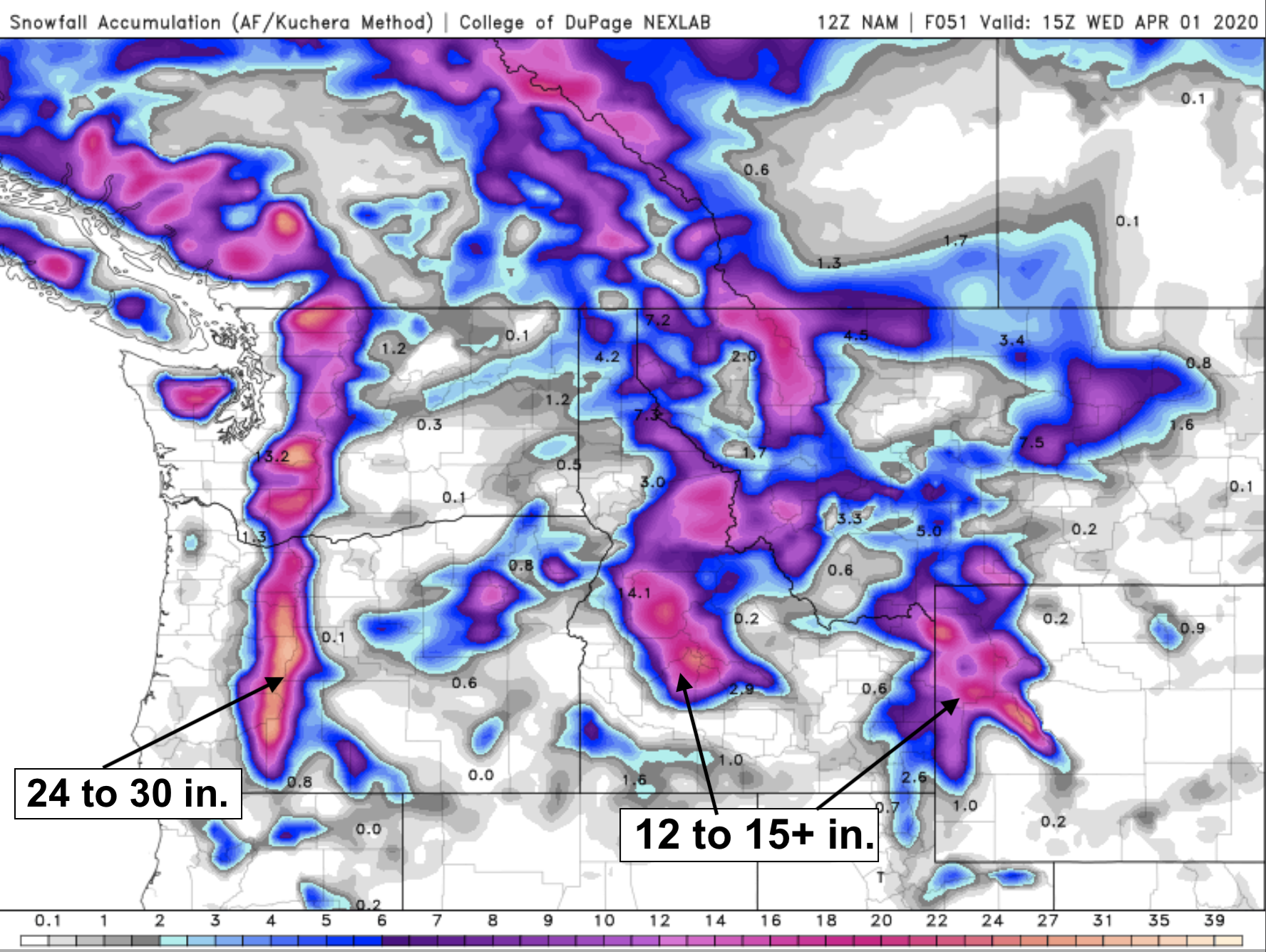
Look like March will go “Out Like a Lion” this year, across the Northwestern United States.
Post by meteorologist Jim Woodmencey
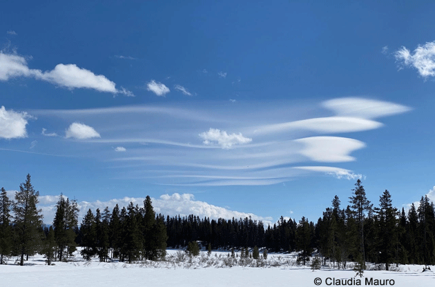
Lee Wave Clouds
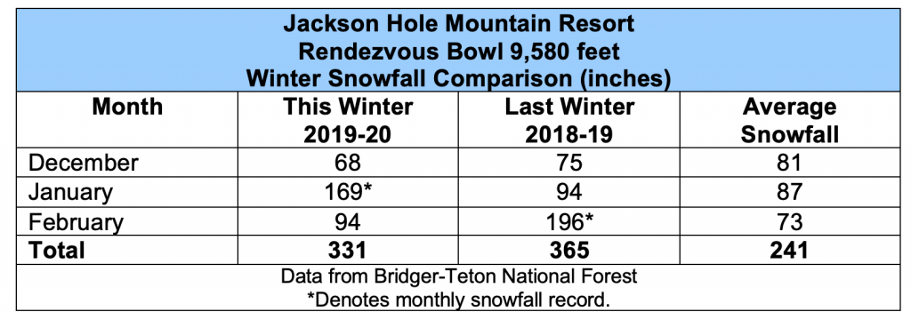
Jackson Hole Winter 2019-20 Review
The “meteorological” winter season is officially ended, defined by the months of December, January and February. The astronomical winter season, which began on the Winter Solstice (December 21st, 2019), runs until the Spring Equinox on March 19th this year.
Below is a re-cap of all the highs and lows and snow that we experienced here in Jackson Hole this winter season.
December 2019: Cold and Dry
In the Town of Jackson, temperatures this past December were colder than normal. The average high temperature was 27-degrees, two degrees below average. The average low temperature for the month was 2-degrees, which was five degrees colder than December’s long-term average low temperature.
Precipitation and snowfall were both well below normal in December in town, with 0.82 inches and 11 inches, respectively. Average precipitation in town in December is 1.52 inches, whereas, the snowfall averages 17 inches.
The mountains were also behind in the snowfall department during the month of December. At the Jackson Hole Mountain Resort, at the Rendezvous Bowl study plot (at the 9,580-foot elevation), total snowfall in December was only 68 inches, compared to a long-term average snowfall in December of 81 inches.
January 2020: Warm and Wet
Where December lagged behind, January more than made up for it, in both temperature and precipitation.
on Togwotee Pass
In town, the Jackson Climate Station had an average high temperature of 30-degrees this January, which is three degrees warmer than the long-term average high. The average low temperature in January 2020 was almost 14-degrees, 13.6 F to be exact. That is nearly ten degrees warmer than the long-term average low temperature in January of 4-degrees.
Precipitation was well above the average, with 2.06 inches in town in January, more than a half-inch above the long-term average of 1.52 inches. Snowfall also exceed the average this January, nearly twice the long-term average. January 2020 had 36 inches of snowfall recorded in town, compared to an average in January of 19 inches.
The Jackson Hole Mountain Resort had a banner January for snowfall, shattering the old January snowfall record. The Rendezvous Bowl site recorded 169 inches of snowfall in January 2020, blowing past the old January record of 150 inches from January 1998. To put that in perspective, the average snowfall in January up there is 87 inches.
January 2020 became the third snowiest month ever recorded at JHMR. Only December of 1996 with 225 inches, and February of 2019 with 196 inches, had bigger monthly snowfalls on the mountain.
February 2020: Cold and Snowy
February began looking like it might be a warm one, with high temperatures in the lower 40’s the first two days of the month. That was just a tease, as the Town of Jackson Climate Station recorded an average high temperature this February that was a full four degrees colder than normal, 28-degrees versus 32-degrees.
The average low temperature this February was 0.6-degrees, which was also much colder than normal, nearly seven degrees colder than the long-term average low temperature in Jackson of 7-degrees.
The coldest day of the Winter of 2019-20 was on February 20th, 2020 when it got down to 25-degrees below zero. That also tied the record for the coldest temperature ever recorded in Jackson on that date, tied with February 20, 1955.
Precipitation in town came in below average by only a tenth of an inch. However, snowfall in February was above average, with 20 inches recorded versus our average February snowfall of 14 inches.
February 2020 snowfall in the mountains was also above average, with 94 inches at the Rendezvous Bowl site compared to the historic average of 73 inches for the month of February. Nowhere close to February 2019’s record snowfall of 196 inches.
Summary: Colder & Snowier than Normal
Overall, the average high and low temperatures in the Town of Jackson were colder than normal for the meteorological winter of 2019-20. Each registered one-degree Fahrenheit below the historic averages for that three-month period.
Precipitation ended up only a quarter inch shy of average, with 3.91 inches versus the average total precipitation for December through February of 4.16 inches.
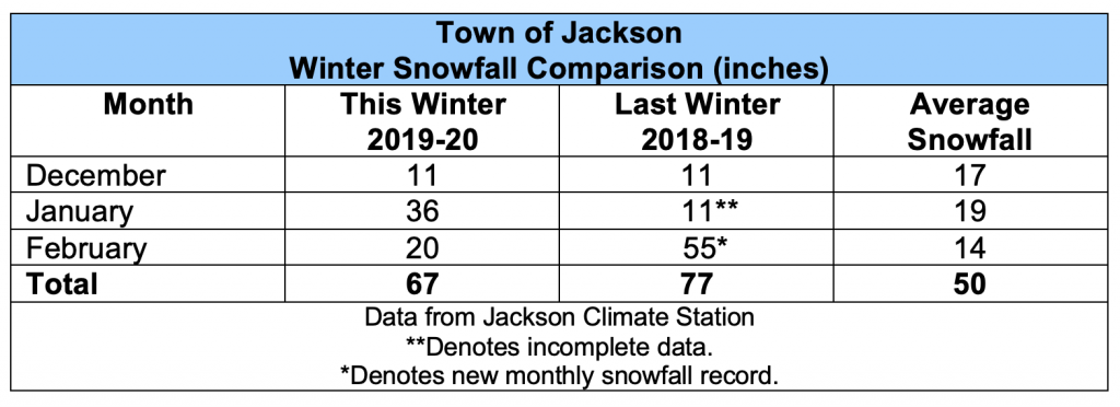
Snowfall was resoundingly above average this winter in town, with 67 inches of snowfall recorded at the climate station, compared to the long-term average for December through February of 50 inches.
Mountain snowfall also checked in with a total for the three-month period of 331 inches. That was a little less than last winter’s 365 inches for the same time period. Although, this winter still received 90 inches more snow than the historic average snowfall total for December through February, of 241 inches at Rendezvous Bowl.
Post by meteorologist Jim Woodmencey
Most of this post originally appeared in the March 11th, 2020 issue of the Jackson Hole News & Guide.
Record March Snowfall in Jackson, WY
On the last day of this Corona-Virus-shortened ski season the Town of Jackson and the Jackson Hole Mountain Resort both broke snowfall records. That happened just when we thought spring was arriving early this March.
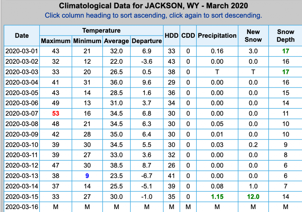
Town Snowfall Record:12 inches of new snow was recorded at the Jackson Climate Station on the morning of March 15th, 2020. That 24-hour snowfall was recorded between 9am Saturday & 9am Sunday, March 14 to 15. That broke the old record for this date of 5.5 inches in 2006.
That also exceeds the previous “official” one-day snowfall record for the month of March in the Town of Jackson of 10 inches, from March 17, 1971. Jackson only averages 11 inches of snow for the entire month of March.
Note: There is one other snowfall recording from March 12th, 1906 that showed 12 inches in one day, and another from March 25th, 1907 that showed 14 inches in one day. These recordings are not from the Town of Jackson, but from an unverified location on a ranch outside of town, possibly near Ely Springs.
Precipitation: In the precipitation department, the Jackson Climate Station received 1.15 inches of water in that snow recorded on Sunday morning March 15th, 2020. That is the second greatest one-day precipitation amount ever recorded in one-day during the month of March, behind March 3rd, 1995, when 1.80 inches was recorded.
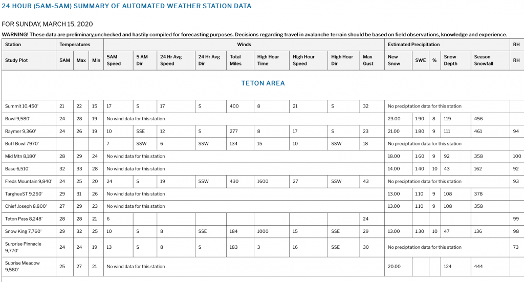
JHMR Snowfall Record:At the Jackson Hole Mountain Resort, at the Rendezvous Bowl Site ( 9,580-ft.) 23 inches of snow was recorded on the morning of March 15, 2020. (measured from 5am Saturday to 5am Sunday March 14 to 15). That exceeds the old one-day snowfall record up there for that date of 16 inches, from March 15, 2016.
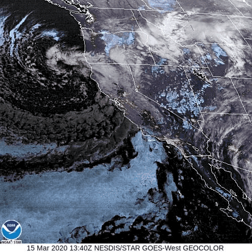
The Storm that Brought The Snow
Below is a Satellite Image showing the Low-pressure that is parked along the Northwest Coast rotating Pacific moisture inland from California to Wyoming the last 2 days. The center of that Low will shift south along the West Coast the next 2 days, bringing Jackson, WY lesser amounts of snow trough the early part of the coming week.
Posted by meteorologist Jim Woodmencey
Wave Clouds

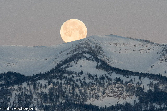
Moonset Behind Glory