
All posts by Jim Woodmencey
Spring Colors

Snow in June
Update Saturday morning, June 8th: (scroll down to read post from Friday)
Forecast verifying pretty well, seeing snowflakes in the Town of Jackson this morning. Snow on the ground down to around the 6,500-ft. elevation.
Grand Targhee is showing over 10 inches of new snow overnight and early this Saturday morning. Screen shots from webcams below….

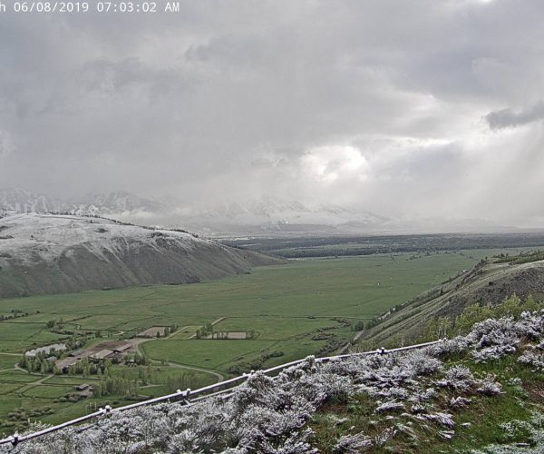

How unusual is snow in June? Not too unusual, but accumulating snow in Town (elevation 6,200-ft.) in June is rare. The record one day snowfall in June in Jackson was 4 inches on June 18th, 1973.
Post From Friday, June 7th:
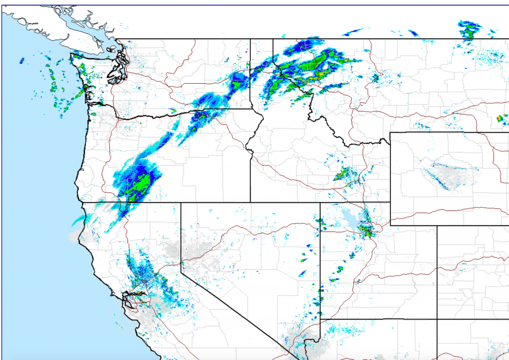
A cold Low-pressure system will be moving across the Pacific Northwest & Northern Rockies Friday & Saturday, June 7th & 8th. This will bring some rain, a few thunderstorms, and a mix of rain and snow to the mountains of Northwest Wyoming. A cold front is currently stalled over central Idaho, but it will progress eastward the next 24-hours.

Snow in June
Yellowstone National Park will see more significant accumulations of snow late Friday night/early Saturday morning. As well as, the Beartooth Mountains of Southwest Montana. Lesser amounts in the Tetons, Wind Rivers, & Bighorns of Wyoming. Snow levels will be low enough to possibly create a mix of rain and snow in Jackson Hole.

Better Weather Sunday
Good news is, all this weather moves east of the Rockies later Saturday, with drier weather & warming temperatures Sunday into Monday. Click the Forecast Weather Map below to see where the worst weather will be the next few days, across the USA.

Post by meteorologist Jim Woodmencey
Weather Pattern Changing
Weather is changing across the Western U.S. for the weekend…..Warm air in place ahead of a cold Low-pressure center positioned off the Pacific Northwest coast this morning. Isolated areas of early morning Thunderstorms started popping up at sunrise. An indication that the atmosphere is already quite unstable.
Satellite & Radar Images, plus lightning strike map from @ 0700 MDT Thursday, June 6th, 2019 below. (Today is the 75th Anniversary of D-Day, by the way).


Below is Thursday’s Forecast Weather Map across the USA. Click the map to view the general weather outlook for next 3-days…..

Further updates on this weekend’s weather situation coming on Friday morning….
Post by meteorologist Jim Woodmencey
Belated Memorial Day Rememberance

Memorial Day Weekend Weather
In General:
The weather across the western U.S. this Memorial Day Weekend won’t be all bad, but it would be hard to call it “good”.
One large, cold trough of Low-pressure will move east of the Rockies Friday. Thursday’s jet stream map below, showing how far south the Low & the jet have been this week.

Now, click on the map above to see the jet stream pattern through Sunday night, May 26th. Once the current Low exits, another Low-pressure moves inland over the Pacific Northwest, which will take another dive towards the Southwestern U.S. The weather pattern the next few days reminds me of a softball pitcher winding up……
That keeps the temps seasonably cooler through Memorial Day over the West, along with showers, thunderstorms and some mountain snow in the picture.
Yes I said, “Snow”!
More cold and more snow for late May 2019. Click Map below for a loop of where, when and how much snow the Western mountains are forecast to get.
Map below shows total accumulation through Sunday afternoon.

In Western Wyoming:
Moisture will again be pulsing across western Wyoming this weekend. Expect showers, heaviest rain looks to be coming on Friday. Maybe another dousing Saturday afternoon. Scattered showers for Sunday & Monday, a little less wet?
Check the forecast for Jackson Hole & the Tetons for more detailed & updated info.
Click on map below for the forecast precipitation, for each 3-hour increment, from Thursday afternoon to Monday afternoon, for the Northwest portion of the U.S.
Find your breaks to get outside!

Post by meteorologist Jim Woodmencey
Record Late May Snowfall
Snow is not all that unusual in the mountains of the Western United States in late May. However, snow to low elevations is a more rare occurrence.
A series of cold Low-pressure systems have been marching across the West since this past weekend. These Lows have brought unusually cold air inland, producing measurable snowfall in the Town of Jackson, Wyoming and to many areas of Colorado.

Jackson, WY
Jackson’s official climate station reported one inch of snow on Monday morning May 20th, 2019. That is the first time in Jackson’s history that measurable snowfall has been recorded on that date.
That’s not to say it hasn’t happened, as missing observations, or snow that melts before it gets measured and recorded are quite possible.
Other dates with measurable snowfall in late May in Jackson include:
1 inch on May 22nd, 1966 (53 years ago).
2 inches on May 30th, 1978 (4 years ago).
3 inches, on May 21st, 1931 (88 years ago).

Denver, CO
On May 21st, 2019 Denver experienced its biggest snow in 44 years, with 3.4 inches recorded in a 24-hour period. That is the most snow in one day in late May, since May 29th, 1975 when Denver recorded 5.6 inches of snow.

Denver also tied a record cold low temperature on May 21st, 2019 with a reading of 31 degrees F.
Even more impressive is that the high temperature only made it to 39 degrees F. That is the coldest May 21st in 128 years! The old record cold high temperature for May 21st was 40 degrees, set way back in in 1891.
Post by meteorologist Jim Woodmencey
Weekend Weather Rap: 17 MAY 2019
Large Low-pressure system on West Coast will continue to cycle clouds and precipitation in and over the Western U.S. and Rockies through the weekend. Rain at lower elevations & snow in the mountains, generally above the 6000-7000-ft. elevations.
Current Situation
Below are this morning’s Satellite & Radar Images: Friday May 17, 2019


Weekend Forecast
Below is an animation of the clouds (represented by gray & white colors) and precipitation (blue-green colors), along with surface pressure contours (white lines in millibars). Video courtesy of Windy.com
Click on image below to view forecast maps from: Friday noon to Sunday evening.

Big Low-pressure rotates moisture inland in pulses, with plenty of clouds & showers each day, Friday through Sunday. Expect periods of heavier rainfall, and just a few breaks in the clouds & showers.
Also, much cold air is coming inland, cold enough in Jackson Hole for the possibility of some snow to the valley floor.
Another Low-pressure center in the Gulf of Alaska will be moving inland later Sunday and affecting the weather across the Western U.S. for most of next week, keeping it wet & cool.
Post by meteorologist Jim Woodmencey
April Sunset

April Avalanches GTNP
