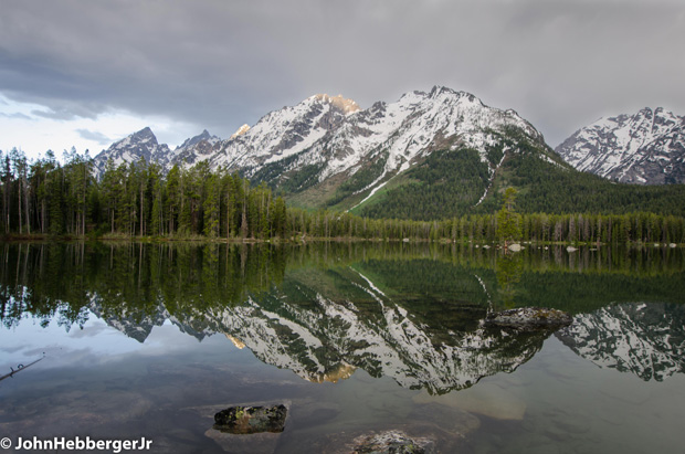
Summer’s unofficial start is always over Memorial Day, and I believe most folks are expecting to have nicer weather from now until at least Labor Day.
There is a general expectation that summer weather will be “warm and sunny”, however, there have been some summers that weren’t, like 1993, which was cold and wet in Jackson Hole, for all three months. Or, other’s that were too warm and too dry, like 1988, the year of the big Yellowstone fires, as well as, more recent summers in the early 2000’s.
I’d venture to say that an “ideal” summer would be defined as: “warm and sunny most of the time”, but not too hot, and not too cool, and not too wet, but not so dry that we have big forest fires. A few thunderstorms are OK, but not on the days I am planning an outing, and never on the weekends, please.
With that, I will take a look at what the long-range outlook is for the Summer of 2017. If for no other reason, to give us a baseline of what we should expect of the weather, in general, over the next few months.
Temperature Forecast
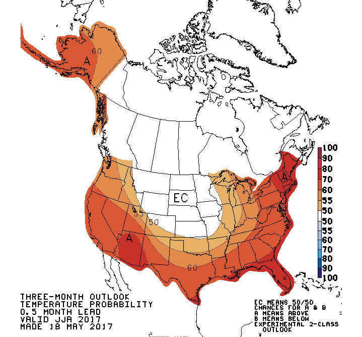
The long-range outlook for temperatures across the United States for June, July and August of 2017, from the Climate Prediction Center, a branch of the National Weather Service, shows that we have “equal chances” of being either above or below normal.
Can we just interpret that to mean that temperatures will be close to average this summer? You can, if that makes you feel better. But what that really means is that the forecasters have no clear indications, one way or the other, that it is going to be warmer or cooler than normal, around here. Those “equal chances” in the temperature category hold true for all of the Northern and Central Rockies, as well as, the Northern and Central Plains States.
Where it is supposed to be warmer than normal, is over the far Western and Southwestern United States, as well as, the entire eastern United States. So, in a relative sense, the Rockies are looking pretty cool for this summer.

Precipitation Forecast
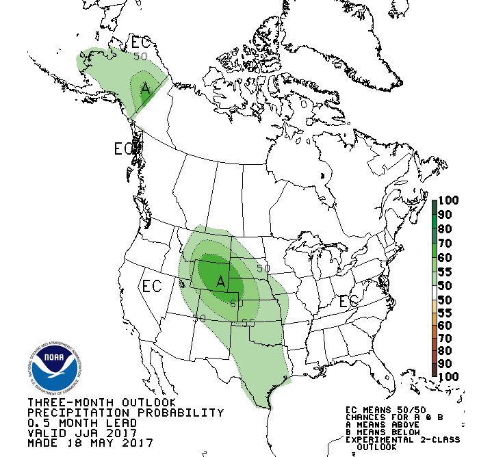
When looking at what parts of the country are supposed to be wetter than normal this summer, that whole picture is pretty much inverted from the pattern shown for temperatures.
The Rockies and Plains States, from north to south, are forecasted to be wetter than normal. As a matter of fact, the State of Wyoming is painted underneath the very highest probabilities of having wetter than normal conditions this summer.
Meanwhile, the far Western and all of the Eastern United States are under “equal chances” of being either wetter or drier than normal. Again, that means forecasters are flipping a coin about wetter or drier for those geographic areas. I suppose “equal chances” sounds more professional than, “I don’t have a clue”.
Summer Summary
What should we make of all that, and how can we summarize what kind of summer to expect? Here’s my take: when we have a wetter than normal summer, we usually have cooler than normal temperatures. Therefore, expect more frequent storms, fewer episodes of long-lasting high pressure, and record breaking high temperatures will be less likely, as well. That should hold true throughout most of the Rockies.
For other parts of the country that are showing a forecast of above normal temperatures, I would expect it to be drier than normal there, as heat tends to follow drought.
Keep in mind that these three-month seasonal outlooks are generalizations, it is what the overall temperature and precipitation should come out looking like when it is all said and done the end of August, when compared to the long-term averages.
To gauge how well these outlooks have performed, let’s look back at October 2016 and the outlook for the Winter of 2016-17. For temperatures, the Climate Prediction Center forecasts gave us “equal chances” of above or below normal. I’d say that was spot-on, as the first half of winter was colder than normal and the last half was warmer. For precipitation, they gave us a better than a 50-percent chance of being above normal. In hindsight, that could have been 100-percent.
If this summer’s outlook turns out to be just as good as this past winter’s, then expect some ups and downs with temperatures, and greener grass in the valley.
Jim is the chief meteorologist at mountainweather.com and has been forecasting weather in Jackson Hole and the Teton Range for more than 25 years.