All posts by Jim Woodmencey

Winter Storm Warning…and other Weather Alerts

Meteorologist Jim Woodmencey

Good timing on the weather!
In last week’s Jackson Hole News & Guide I primed you with an article about NWS
Winter Weather Advisories, Watches, and Warnings….what they mean to you.……and here we go, with a “Winter Storm Warning” for Jackson Hole issued Wednesday mroning, which was upgraded from a “Watch” that was issued on Tuesday morning.

Mountain Weather Column
Jackson Hole News & Guide
January 22, 2014 Issue

During the course of the winter season we will see a number of different weather alerts issued by the National Weather Service Office in Riverton, which is responsible for issuing weather warnings for all of western Wyoming.
In this week’s column I will delineate for you the different types of Advisories, Watches, and Warnings you may come across during the winter season, what the criteria is for issuing them, and what they really mean to you.
Advisories


The National Weather Service will issue Winter Weather “Advisories” to alert the public to weather situations that may present a hazard, but do not meet the “Warning” category criteria. “Advisories” are for weather that may cause significant inconvenience or difficulty to travelers. 
The earliest type of advisory you may see is a “Hazardous Weather Outlook”, which may be issued several days ahead of time if a large storm system is expected, which might affect travel. Other wintertime advisories and their criteria are listed below.
Winter Weather Advisory:  Most commonly issued for snow events or when a combination of precipitation is expected; such as: snow, sleet, freezing rain, or blowing snow, is in the forecast.
A Snow Advisory would be a more specific type of Winter Weather Advisory that would be issued when snowfall is expected to be between 3 and 6 inches in 24 hours in valley locations. Mountain locations have snow advisories issued when between 6 and12 inches of accumulation is expected in 24 hours.
Blowing Snow Advisory: Issued when wind-driven snow intermittently reduces visibility to ¼ mile or less. Travel may be hampered.  Strong winds can create blowing snow by picking up old or new snow.
Other winter advisories you might see are: Wind-Chill Advisory (-20F) or a Dense Fog Advisory (¼ mile visibility).
Watches and Warnings
“Watches” and “Warnings” are more serious than “Advisories”.
A “Watch” is issued when conditions are favorable for the development of a particular weather event that meets certain threshold criteria.  A “Warning” is issued when a particular severe weather condition is imminent or actually occurring. “Watches” & “Warnings” are usually reserved for weather situations that will make travel impossible, or could pose a threat to life and property.
Note: Be aware that the criteria used for Advisories and Warnings is different for different locations across the country.
“Watches” are intended to provide enough lead-time so that people can adjust their schedules. “Watches” may be issued up to 48 hours in advance of the event and generally will precede a “Warning”. 
When a Watch is upgraded to a Warning, you should take it very seriously. Listed below are the most common Warnings you may see issued in western Wyoming.
Winter Storm Warning:Issued when heavy snow and/or strong wind are possible.
Winter Storm Warning for Heavy Snow: Issued when snowfall is expected to exceed 6 inches per event in the valley. For mountain locations it is 12 inches or more per event.
Blizzard Warning: Strong winds of 35 mph or greater, cold temperatures, and considerable falling and/or blowing snow that frequently drops visibility to ¼ mile or less. And these conditions are expected to last for 3 hours or longer.
Other Warnings might include: Wind-Chill Warning (-30F) or an Avalanche Warning (High to Extreme Avalanche danger rating).
Winter Weather Advisory & Warning Criteria for Heavy Snow in Western Wyoming
Per Event or Time Period
Advisory
Warning
Valley
3 to 6 inches
6 inches or more
Mountains
5 to 12 inches
12 inches or more
From NWS Central Region
While a “Winter Storm Warning” may not necessarily translate to copious powder for skiers, it should at least mean that we are in for some nasty weather involving snow, wind, bad visibility, and sporty driving conditions.
Blizzard, Winter storm, and Avalanche Warnings are serious enough to be sent out on the Emergency Alert System (EAS), and if you subscribe to NIXLE alerts, you should see them show up there, as well.
On the MountainWeather.com website on the Jackson Hole Forecast page, a flashing box will appear at the top of that page above the forecast content whenever the National Weather Service in Riverton has issued any sort of weather alert specifically for Teton County. Read these carefully, and don’t just assume the flashing box means a big dump is on the way!
Post by Meteorologist Jim Woodmencey
Republished with permission from JH N&G

Jackson was Colder & Drier than Normal in 2013

Meteorologist Jim Woodmencey
 
This article first appeared a week ago in the Jackson Hole News & Guide’s Mountain Weather column, by meteorologist Jim Woodmencey and is republished here on the mountainweather blog…….

To characterize the entire year 2013 in Jackson as “colder and drier” than normal, does not adequately describe the actual ups and downs of weather that we experienced here over the previous 12 months. So, in order to give you a better feel for what transpired weather-wise here in Jackson Hole in 2013, I will “break it down”, like an ESPN post-game analyst, quarter by quarter, or season by season.
Winter 2013: January- February
The winter of 2012-13 ended up with below normal precipitation and snowfall in town. Below normal precipitation would a recurring problem until the Fall of 2013.
Temperatures were also colder than normal to start the year, a theme that would also continue throughout the year. The coldest day of 2013 was on January 3rd, with a morning low of 22-degrees below zero.
Spring 2013: March-April-May
For the spring months, temperatures and precipitation stayed very close to average. April was the standout month, with colder than normal temps and above normal precip. The month of May was the snowiest of the three months, with just over 5 inches of snow in town. That was more snow than we had in March and April combined, which is a little out of whack.
Summer 2013: June-July-August
We had less than 50-percent of our normal precipitation in town for the three months of summer. June and August were especially dry. July actually registered a few hundredths of an inch above normal in the climate station rain bucket.
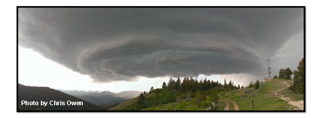
There were also a few notable days with severe thunderstorm activity, large hail, gusty downdraft winds, and one particularly large cell that passed over town in mid-June that looked like it could spawn a tornado at any moment.
Temperatures each month of the summer were about as close to the historic average as you can get. The hottest temperature of 2013, recorded at the Jackson Climate Station thermometer, was 86 degrees. That actually occurred twice in August, twice in July, and also one day at the end of June. We never “officially” hit 90 degrees all summer.
Big thunderstorm cell over Snow King Mountain in mid-June. Nice shot Chris!
Fall 2013: September-October-November
Wet, cold, and snowy would be the best way to describe the fall season. Abundant precipitation in town helped make up for the low water amounts from summer. And snow was accumulating in the mountains by late September.
September was the wettest month this past year, with 2.91 inches of precip in town. The average in September is 1.27 inches. In October we had over 2 inches of precip, and 9 inches of snow was counted in town. That was more snow than we would get in November, and also more than we received in December!
Not surprisingly, September and October were much colder than normal. November was the only month in 2013 that recorded above normal temperatures, just barely. The average high in November 2013 was 40-degrees, which is normal. Average low in November 2013 was 19, the normal is 16 degrees.
Early Winter 2013: December
You could count the snowstorms we had in December on one hand: A good dump in early December, another decent snowfall a couple days before Christmas, and a few extra inches on New Year’s Eve to ring in 2014.
We had about half of our normal precipitation this past December, and less than half of our normal snowfall. Only 7 inches of snow recorded in Town, average December snowfall is 17 inches. (Note: some observations were missing, so this number may be misleading).
One thing is for sure, December 2013 was colder than average, with the month’s average high at 26 degrees, or two degrees below normal. The average low for the month of one degree was six degrees below normal.
Summary of 2013
If you compare 2013’s annual precipitation totals and the average temperatures for the year to the historic averages, then “colder and drier than normal” does sum it up for Jackson’s weather in 2013.
The average annual high temperature was three degrees colder than normal, and average annual low temperature was right at normal. Precipitation was 86-percent of normal for the year and annual snowfall, for the calendar year in town, was 58% of normal.
Annual Weather Stats for 2013 compared to Historic Averages
Annual
High Temp
Annual
Low Temp
Annual
Precipitation
Annual Snowfall
The Year
2013
51°F
23°F
13.69 inches
45 inches
Historic Averages
54°F
23°F
15.83 inches
77 inches
Note: Historic data is from the Jackson Climate Station 1905-2012
 (Note: This post is from the Jackson Hole News and Guide Mountain Weather Column, January 8, 2014)

Jackson Hole’s Snowstorm & Western US Snowdepths

Meteorologist Jim Woodmencey
The storm from this past weekend brought snow, along with a lot of wind to the Jackson Hole area. Around two feet of snow to the higher elevations of the Tetons, containing over 2 inches of water snow from Friday night thru Monday morning. Winds were averaging around 30 mph at ridgetop level, with gusts over 60mph, helping to load leeward slopes and creating dangerous avalanche conditions.
With all the wind we had, it is difficult to get a completely accurate reading of snow or water amounts. It’s hard to chase that snow down when it is falling horizontally!
The Bridger-Teton National Forest Avalanche Center reported on Monday morning that some areas at the higher elevations received as much as 45 inches of snow over the past 4 days, along with 4.5 inches of water.
A summary of data reported during this past week’s storm cycle, taken from the Rendezvous Bowl and Raymer weather plots located at around 9500-ft. at JHMR, is shown in the table below. Almost 3 feet with more than 3 inches of water!
Summary of Snow and Water Accumulation
24-Hour and Storm Totals
Date
Rendezvous Bowl
Raymer
Snow (in.)
H2O (in.)
Snow (in.)
H2O (in.)
Thursday, Jan. 9
13
1.10
10
.90
Friday, Jan. 10
4
.35
3
.27
Saturday, Jan. 11
7
.70
12
.80
Sunday Jan. 12
10
1.20
9
1.10
4-Day Storm Totals:
34”
3.35”
34”
3.07”
Data from BTNF morning weather summaries of preliminary data from these stations.
USA Snow Depths

For many parts of the west, especially the Sierras, it has been a slim snow year, so far. However, parts of West are doing just fine. The North Cascades, Central Idaho mountains, western Montana’s mountains, the mountains of NW Wyoming, and the higher elevations of the north-central Colorado Rockies have some of the deepest snowdepths in the United States as of Monday morning, January 13, 2014. (See maps below).
USA Snowdepths as of January 13, 2014

Zoom on Western US Snowdepths
 
Post by Meteorologist Jim Woodmencey
Data from BTNF
Graphic from NOAA

Get Ready for Snowin’ and Blowin’

Meteorologist Jim Woodmencey

Jackson Hole and the Tetons are going to be in for some decent snowfall the rest of this week. Snow Thursday will get things going with a somewhat weaker storm moving across the Northern Rockies. Then a second storm system that is looking much more powerful, moving across the southern Gulf of Alaska Friday will punch inland for the weekend.

The higher elevations of the Cascades of Washington and Oregon stand to get some significant snowfall. The central Idaho mountains will also benefit with some heavier snowfall.

In the Tetons of western Wyoming, two-feet or more of snow and between 2 and 3 inches of water could accumulate between Thursday morning and Sunday morning. This will be accompanied by strong  winds. And then finish off with a little more snow & wind, and cooler temps, on Sunday.

Forecast Weather Map for Saturday 11 January 2014

Forecast Total Snowfall Amounts Thursday a.m thru Saturday p.m. (Jan 8 to 11)

CAUTION!

PLEASE be careful to not get so jacked-up for skiing powder in the backcountry that you forget to pay attention to the avalanche conditions. Remember, all this new snow is falling on a weak snowpack, and avalanche danger is going to rise, especially with the wind helping to add additional load those slopes!

PAY ATTENTION to the AVALANCHE FORECAST for the areas you like to go to. Get avalanche info for all areas of the Western US on the Skier’s Page of mountainweather.com

If you are going to your favorite ski area, please exercise some patience for ski area workers as they may need extra time to open the mountain and make it safe for you. And also highway avalanche control workers who will doing the same this weekend.

Post by Meteorologist Jim Woodmencey
Graphics from NOAA

Winter Solstice 2013

Allow me to officially welcome you to the start of Winter! Even though it has been snowing and relatively cold here in Jackson Hole for three months already! Remember those first snow storms in the mountains at the end of September?


Despite that,

This creates the shortest days of the year in Jackson Hole at about 43.5 degrees North Latitude, or 67 degrees of latitude further north from where the sun is shining directly overhead.

There is less than nine hours of daylight, and just over 15 hours of darkness this time of year.  Exactly the opposite is true in the Southern Hemisphere, where they will be having their Summer Solstice on December 21.

During the week or two around the Solstice, the length of each day is very similar. The days won’t start getting much longer until well into January. After that, the days will steadily lengthen as we progress towards the Spring Equinox, which is another 90 days away in March.

Post by Jim Woodmencey, meteorologist

Back to a Snowy Weather Pattern for Early December

Meteorologist Jim Woodmencey

After a pretty good drought the last week or so, it looks like the weather pattern is finally changing to get the Pacific Northwest & the Rockies back into some new snow.

Low pressure center developing over British Columbia on Sunday, December 1st, will favor the Washington Cascades and northern Idaho & Montana initially. But some snow will fall in the mountains of SW Montana and western Wyoming.

The jet stream position is a little too far north to bring the best energy further south until Sunday night and Monday, when it drives right over western Wyoming and favors Jackson Hole & the Tetons. Low pressure center over BC moves east along the Canadian border and puts the Teton Mountains under a strong Westerly flow on Monday, finishing up on Tuesday with a colder Northwesterly flow and lighter winds and lighter snowfall.

Snow Amounts

Snowfall amounts should be rather impressive, especially in the Washington Cascades when you include snow accumulations this weekend and through Monday evening. Around 2 feet of new snow should be expected at around the 9,000-ft. elevation, more at higher elevations and in some favored locations. (See snowfall forecast maps below).

Then on Tuesday & Wednesday the focus will shift over the northern & central Colorado Rockies.

Water Amounts

Models are showing impressive water amounts also, with 4 to 5 inches of water forecast through Monday night for the Cascades, and 2 to 3 inches of water content for the Tetons.

It will be interesting to follow this storm and see how much we get. Certainly enough to make some good powder skiing again, and certainly enough to up the ante on the avalanche danger this week….especially combining the amount of wind, water, and snow.

Word of Caution: Be careful how you manage your enthusiasm for powder with the impending hazard in the backcountry!

Forecasted Snowfall Amounts Northwest US thru Monday evening, Dec. 2

Zoom in on same Forecasted Snowfall Amounts Western WY area

Total Forecasted Water Amounts Nov. 30 thru Dec. 2

Jet stream position on Monday December 2 (Red core is over 120 mph)

Posted by meteorologist Jim Woodmencey
Graphics from NOAA, NEXLAB, & LEADS On-line

What does a “No Nino” Winter Mean?

Meteorologist Jim Woodmencey

Usually by now, I will hear some utterance to the effect, “Oh, it’s an El Nino year”, or, “I heard we are gonna have another La Nina”.

“El Nino” and “La Nina” have become buzzwords for ski towns like Jackson Hole El Nino has become synonymous with low-snowfall winters and La Nina with above normal snowfall winters.  No Nino doesn’t seem to have its own buzz, although if you looked at the No Nino winters we’ve had in Jackson Hole over the years, you might tag it as a buzz-killer.

First, let’s get some definition as to what El Nino, La Nina, and No Nino really mean. Collectively, these are known as the El Nino Southern Oscillation (ENSO), a phenomena that is happening down in the Equatorial Pacific. ENSO affects weather patterns around the globe, and these effects are more prevalent during Northern Hemisphere winters.

The ENSO phase we are in is determined by sea surface temperatures found across the Pacific, between the coast of South America and Indonesia.

El Nino is when sea surface temperatures are warmer than normal. La Nina is when temperatures are colder than normal. No Nino is when temperatures are normal, otherwise known as the neutral phase of ENSO.

Generally during El Nino winters, the Pacific Northwest and Northern Rockies experience warmer than normal temperatures and below normal precipitation, while the southern tier of the United States is usually cooler with above normal precipitation.

During La Nina winters, the opposite is true: the northern tier of the U.S. experiences a cooler and snowier winter, while the southern tier is usually warmer and drier.

This is why when we hear El Nino in Jackson, we think, “no snow”. And when we hear La Nina we think, “mo’ snow!” We came out of a weak La Nina last winter and have been stuck in neutral ever since.

Statistically here in Jackson Hole, El Nino winters are evenly split between above and below normal snowfall winters; 50/50. La Nina winters are snowier than normal more like 70-percent of the time. That’s why we get excited about them. But 30% of La Nina’s have had below normal snowfall.

You might surmise that No Nino winters (or Nada Nino) should then be “normal” or “average” winters. An average winter is difficult to define because our averages are created by our extremes. Almost every single winter is either above or below the average, some more than others. Besides, who is going to run around shouting, “Woody said we are going to have average winter!”

In Jackson Hole, winters that were spent in the No Nino phase more often than not produced below normal snowfall; about two-thirds of the 15 winters I analyzed in this category were drier than normal winters. That means that a third of the No Nino winters had above normal snowfall. Most notably was the winter of 1996-97, which was a very big snowfall year.

El Nino Southern Oscillation


Send in the Arctic Oscillation

ENSO isn’t the only thing that can disrupt weather patterns in the winter months. Another phenomenon that is closely monitored is the Arctic Oscillation, or AO.

AO is a measure of the difference in pressure between the Northern Polar Regions & the mid-Latitudes (where we live). This difference creates either a positive or a negative phase.

Positive AO occurs when there is lower pressure over the Arctic Circle and higher pressure over mid-Latitudes. This forces the jet stream and the storm track further north. The result is more ocean storms and wetter weather for Alaska, and warmer temperatures in the mid-latitudes.

Negative AO occurs when there is higher pressure over the Arctic Circle and lower pressure over the mid-latitudes. This forces the jet stream and storm track further south. The result is colder air and more storms in the mid-Latitudes, at the same time warmer air moves up into Alaska.

The problem is that the Arctic Oscillation fluctuates more regularly, from week to week, whereas ENSO fluctuations take longer to switch from one phase to another, on the order of months.

Given the current No Nino outlook for this winter, I will be turning my attention to the North Pole and looking for some “Negative AO” action to drive the storm track further south and right over Jackson Hole. Not sure that’s gonna have the same buzz as La Nina does.

Arctic Oscillation

The content of his week’s blog is excerpted from the Mountain Weather Column I wrote for the Jackson Hole News and Guide in October.
Graphics courtesy of NOAA.

Good Dump of Snow for Jackson to End October

Meteorologist Jim Woodmencey

Nice dump of snow for Jackson last night, with about 5 inches in a couple of hours at my house near Snow King Mountain.  At 7:00 pm there was no snow, by 9:00 pm I was shoveling the deck. As I write this at 5:00 a.m. on Tuesday morning, there is another 4 or 5 inches on the deck. Total of 8 to 10 inches in less than 12 hours. (It is still October, isn’t it?)

This snowstorm was courtesy of a slow moving and very large Low pressure system that moved into the Western U.S. on Sunday. It basically parked itself over the Great Basin Monday and wrapped some cold air from Canada into itself.

For the most part, the flow aloft was out of the South overnight, a flow which favors Snow King Mountain and the Town of Jackson for orographic snowfall, that is, the extra lift the mountains provide to boost the snowfall. The jet stream was also in an optimal position to give an extra boost, as well.

Looking around at other mountain instruments, it seems that 6 to 8 inches overnight was the norm, even up at elevation in the Tetons. So a fairly even distribution from what we received in Town and what fell at 8 to 10,000-ft. in the Teton Range.

After a week of High pressure and sunny weather last week, we switched gears pretty quickly on Monday.

Even though technically I a supposed to be on my “Fall Break” right now, I couldn’t resist looking at this storm. Now our 5th snowstorm in the Tetons since late September.

I am off to Alaska this coming week to teach a weather course. Back to forecasting for JH on Nov. 11th.

Surface Map

700mb Map (around 10,000-ft. elevation)

Jet Stream Map (@ 30,000-ft.)

Post by Jim Woodmencey
Graphics from NOAA

Good Early Snowstorm for Wyoming

Meteorologist Jim Woodmencey

Pretty good snowstorm for the western Wyoming mountains Thursday/Thursday night. But a really good snowstorm for the rest of Wyoming for Friday & Friday night. Winter Storm Warnings and Blizzard Warnings issued for much of the eastern half of Wyoming.

Some snow for the Colorado Rockies with this storm, but the Plains of Nebraska and South Dakota really get hammered by this weather system as it moves east Saturday.

From NWS Office Cheyenne
Issued Friday morning Oct. 4
NWS Nationall Forecast Map for Friday Oct. 4

Snowdepths Getting Deep for Early October
Up in the Teton mountains there is now a foot or more of snow up around the 9,000 to 10,000-ft elevation being reported on the few instruments that are up and running. For instance, the Snotel sensor at Grand Targhee at an elevation of 9260-ft. is showing a 13 inch snow depth.

The Snotel sensor on Togwotee Pass at the 9850-ft. elevation is showing 16 inches of settled snow depth at 8:00 a.m. on Friday, October 4th. 

Over in the Wind River Range, which stands to get the most snow from this storm as it is now more of an “upslope” event for areas along and east of the Continental Divide (as the Low pressure center moves into Central/Eastern Wyoming), there dis even more snow on the ground now. Hobbs Park Snotel is at 10,100-ft., along the eastern side of the Winds, and it shows a 20 inch sow depth this morning.

Oh, and by the way, the temperature up at around the 10,000-ft. elevation this morning is 18 degrees. I guess we are skipping Fall and heading right into Winter.

 Forecasted Snowfall Amounts
RAP Snowfall forecast map of total snow accumulation Friday morning thru Friday Evening
WRF Total snow accumulation forecast for Friday morning thru Saturday morning.

Keep track of Jackson Hole & Wyoming Weather & Snowfall

If you want a quick way to check out all the local weather instruments, go to the “WAM” (Weather Access Map) for the Jackson Hole & Yellowstone area…..click here: WAM Tetons

There is also a “WAM” for the State of Wyoming……click here: WAM Wyoming

Both of thees maps will get you to the latest data and also the latest forecasts for those same locations.
(Note: Utah & Colorado WAM’s will be available soon, hopefully soon enough!)

Post by meteorologist Jim Woodmencey
Maps courtesy of the NWS

What the Big Storm Left Behind…..

Meteorologist Jim Woodmencey

The big storm that brought rain and snow this week to the Northwest and the Northern Rockies will be moving across the central Rockies and the northern Plains the next 24-hours or so.

What it left behind was fairly impressive, with record September snowfall at Crater Lake National Park in Oregon of 8 inches in 24-hours Tuesday into Wednesday, above about the 6,000-ft. elevation.

At the Jackson Hole Mountain Resort there was also about 8 inches of snow reported up there at about the 9500-ft. elevation, which accumulated from just before midnight Tuesday through Thursday morning Sept. 26th. Togwotee Pass had about 10 inches at the same elevation. And the higher elevations in the Wind River Range had more than that, and appear to have the deepest snow accumulations from this storm.

Rain in the Town of Jackson was also significant, at the automated rain gauge in town 1.26 inches of rain fell in less than 24-hours. Significant because the average rainfall for the month is 1.29 inches.

See precip and snowfall coverage maps below from this storm.

One Day’s Precip on September 26th across the Western US

Zoom on Northwest US One-Day Precip Sept. 26

Zoomed into Wyoming One-Day Precip Totals Sept 26.
US Snow Depth Map on morning of Sept. 27th
Zoomed in Snow Depth Map for Western WY
Post by meteorologist Jim Woodmencey
Graphics from NWS