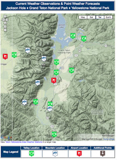
All posts by Jim Woodmencey

Where is All the Snow?

Usually by around Halloween skiers start thinking more about winter than they are about fall sports. If you remember last year at this time the Northern Rockies were already blanketed with 2 to 3 feet of snow between October 23 & 26, 2010 and people were backcountry skiing like it was early December.

Yesterday I took a mountain bike ride (while thinking about skiing!) with Chris Harder who told me he had skied “25-short” in Grand Teton National Park, to the valley floor, on October 28, 2010. What a difference a year makes.

This year, on October 25 & 26 the Central Rockies of Colorado got the big early season dump with 10 to 15 inches in 24 hours and more than 2 feet total in some locations this week. That storm extended from Wolf Creek in the Southwestern part of the Colorado Rockies all the way across the State to Eldora just outside of Rocky Mountain National Park in the northeastern part. (Map below shows snow depths as of Oct. 28, 2011 in Wyoming & Colorado)

Also, parts of the Northeastern U.S. have already had some pre-Halloween snowfall, from the Catskills of New York to the mountains of Vermont and New Hampshire (pronounced “New Hampsha”). They got good snow this past week also, albeit less than 10 inches in most places. The other area that was getting heavy snowfall this week was the mountains of British Columbia and into the Canadian Rockies.

Some skiers in the U.S. Northern Rockies might already be saying where’s ours? With all the hype about it being another “La Nina Winter” I think people expect a repeat of 2010-11. And while we may end up with an above normal snowfall winter again in Jackson Hole, the distribution of that snowfall may not necessarily be identical to last year, nor as continuous like it was from late October to late May!!. It’s already different than it was last year going into this winter.

Keep in mind as we go through the next 6 months, that no two La Nina’s are created equal.

Keeping Track of Who Has the Snow

If you are planning ski trips this winter you can keep track of where the snow is, across the entire USA and southern Canada by going to www.mountainweather.com and getting on the Skier’s Page under the “Additional Mountain Weather” drop-down menu.

Here you will find links to ski areas throughout the US, with a concentration of links and more information for western U.S. ski areas. Also links to the latest Avalanche Advisories are midway down the page, for the backcountry skier.

At the bottom of the page is where you’ll find snowfall and snowdepth info in more detail. (An example of the National Snow Depth map is shown below).

There is also a link in the Quicklinks box in the upper right hand corner of the Skier’s Page that will take you to the National Snow Analyses page that is updated daily by NOAA.

If you are a real snow-nerd, you can keep up with everything from snow depths, to snow-water equivalent, to sublimation throughout the early season and over the course of this winter.

Posted by meteorologist Jim Woodmencey
October 29, 2011

First Snow of the Season!….and La Nina Update

It has arrived, the first snow of the season, and it is only Oct. 6th. An unusually cold Low pressure system covering most of the Western U.S. with a huge counter-clockwise circulation around it, brought snow this morning to the valley floor in Jackson Hole. Generally about 2 inches in the valley, with maybe 6 inches at higher elevations, but not too much more than that at this point (end of day Thursday). But before it is done later Friday, there might be 10 or 12 inches at higher elevations in the Tetons.

This storm began putting down some decent snow in the Sierras the day before. And temps were cold enough aloft to bring snow down to fairly low elevations. Even Salt Lake City at 4500-ft. had a couple of inches of snow today.

This is all coming after about a ten-day stretch of nice Indian Summer weather in late September and high temps in Jackson hitting 80 degrees just one week ago!
Below are some pics from webcams around the region showing the new snow today:

Town of Jackson & Teton Pass

Sun Valley, ID & Snowbird, UT

Compared to Last Fall
Last year we had our first good snowfall in the mountains on September 10th, with almost 12 inches at 9,000 to 10,000-ft. in the Tetons, but snow levels only reached down to around 8,000-ft.

Then it went warm and dry for a month, until October 23rd when it snowed to the valley floor and ended up throwing down 2 to 3 feet at the higher elevations over the course of 4 days. And of course the rest of last winter is legend. It never really stopped snowing until sometime in June!! “Viva La Nina”, the skier’s chanted.
Well, it looks like they may get their wish…….

La Nina Update
The latest update to the ENSO forecast came out today…………read all about it first hand by going to the bottom of this page ….NWS Discussions & Outlooks ….and click on current the ENSO Discussion or peruse the long range outlooks or go to the La Nina page and learn more about the phenomena to impress your friends during Apres Ski.

The short of that report is: La Niña conditions are expected to gradually strengthen and continue through the Northern Hemisphere winter 2011-12.

It goes on to say that this one is not as strong as last year’s La Nina.
So, while it may not be as strong, it is at least showing a trend of sticking around through the winter, which should be good news for a more northerly storm track that favors the Northwest and Northern Rockies especially.

We will forever equate last year’s La Nina with bountiful powder that went on and on into the spring. That will be what we expect all La Nina’s to do. And that is simply not the case. Just like the proverbial snowflake, no two La Nina years are ever exactly alike, but the odds at least favor an above normal snowfall winter.

The Outlook for this Winter

This time of year the most popular question I get asked is, “What kind of winter do you think we’ll have?” My standard response is, “Snowy!”

The real question though on everyone’s mind is, exactly how snowy will it be? After all, more snow equates to a better ski season.
So, the real quest is to try and give everyone a heads-up on how early will the snow come and will it keep coming right through the whole winter season…..and then somehow magically stop on April First, when we want the weather to turn to spring. By that time of year, the question becomes, when is it going to get warm and sunny?!!
Long Range Outlook
There are a number of sources for long-term weather forecasts, most of which are pretty general, that is, they only say if it’s going to be warmer or colder than normal, drier or wetter than normal.
The Farmer’s Almanacs for 2012 will be coming out soon, and there are several versions these days, which each have their own secret formula for predicting the next year’s worth of weather. But if you read them closely, they hedge back and forth to cover a variety of possibilities, and they can be confusing or misleading about what is going to occur. The regional seasonal forecasts don’t always jive with the specifics of the monthly/weekly breakdown.
On the NWS Discussions & Outlooks page of mountainweather.com I have put together a collection of Long Range Outlook information that you can peruse. These include 6 to 10 day outlooks, 8 to 14 day outlooks, 30-day and 3-month seasonal outlooks. Then, if you click on the link in red to “Climate Prediction Center Seasonal Outlook Page”, you can get an outlook for the next 12 months…..right through September 2012.
This year’s early fall outlook, September through November, for precipitation over the northern Rockies is “EC”, which means “equal chances” that we will experience above, below, or normal conditions. Oh, that’s helpful. Only the far Pacific Northwest Coast is expected to be wetter than normal.
Temperatures between now and November are also in the EC range for the far northern Rockies, to warmer than normal for the central and southern Rockies.
As we get into the meat of winter, December through February, precipitation for the northern and central Rockies remains at “EC”, and only the Pacific Northwest, now including Northwest Montana is shown to have above normal precip.
The Pacific Northwest is also shown to be colder than normal for this time period (see maps below). Could that spell a winter of drier, lighter, powder for the Cascades? That would certainly be an anomaly!
Precipitation Map below for December-January-February

Temperature Map below for December-January-February


Keep in mind these are general “outlooks” over 3 month periods, not spot-on “weather forecasts” of big snowstorms or drought. They are general trends based on a bunch of different computer models and inputs. Subject to change as the weather actually changes!These get updated on an almost weekly basis.
At the bottom of the page is information about El Nino/La Nina. Most skiers are very in-tune to this phenomena, and I think it helps keep the world simple for them……La Nina means lots of snow and El Nino doesn’t.
Winter 2011-2012 Outlook
Simply put, last winter we had La Nina conditions all fall, winter, and into spring and it was very snowy from October through May. La Nina did what she was supposed to for the Northwest and the Rockies, even the Sierras, where she wasn’t supposed to!
Currently we are under what is known as a “Neutral” condition, neither El Nino nor La Nina. In other words, sea surface temperatures in the equatorial Pacific are normal.
The latest prediction is for that to continue this fall and then either stay Neutral for the winter or trend towards a La Nina again. And a new forecast comes out this week….so stay tuned.
Last winter’s La Nina was a strong one, and for us to get another winter like we had in 2010-2011 would be pretty hard to beat, or repeat.
Bottom-line is, when you look at all the outlooks, it seems like we are in for what might be considered a “normal” winter in the northern Rockies and Jackson Hole.
Essentially at this point to say we’ll have a snowier than normal winter or a drier than normal winter would be throwing a dart. Saying it’ll be snowier than normal will sell more season passes pre-season. Saying drier than normal will only bum out the ski crowd pre-maturely.
My experience has been that most folks will put their faith in whichever forecast is predicting the kind of weather they want to see happen. And they hang their hat on that almanac, or that outlook, or that La Nina forecast.
One thing I can say with some certainty, at some point this winter season it will be snowy! And at some point someone will ask, when is it going to stop snowing?

New Lightning Map for Jackson Hole

The Lightning Detection system I spoke of in the last MountainWeather Blog is now up and running and working pretty well. “Live” lightning strike data is now available for Jackson Hole and it can be viewed by going to mountainweather.com and clicking on the Lightning Map under the Jackson Hole drop down menu. Or, just click this link: Lightning Map.


Sample Map from this past Thursday Night’s Thunderstorms, before they hit Jackson.

Reading the Maps

If you open another browser page along side this one, I will guide you through how to read and interpret these maps. Once you have the Lightning Strike Map page open, you will find two maps on this page………. Along with local satellite and radar map sat the bottom.

The top map is a “static” map or a “screenshot” that is zoomed out to 63 miles from the center. The white rings are in miles from the center, and the center of the map is right over the top of Snow King Mountain, just above the Town of Jackson. The large red ring is the 50-mile mark, out from center.

The lower map, further down the page, is an “active” map that goes out to 180 miles from center. It has some user controls that allow you to zoom even further out, to have a look beyond 300 miles. What you see out that far though is unreliable. From the testing done over the last month or so, I have found the useful range of this instrument to be between 120 and 150 miles. Beyond that, the accuracy of strike placement and detection of all strikes is inconsistent. This system has been working really well tracking the location of strikes and thunderstorm intensity within a 60 to 75 mile radius.

The symbols on these two maps are roughly the same. Big red dot is a recent negative ground strike and big orange dot is a recent positive ground strike. Most important difference between the two is the positive ground strikes are much more powerful, and are usually the strikes that kill people or start fires.

The + and – symbols are in-cloud lightning flashes, either between two clouds or within a single cell. These bolts are not striking the ground, but they may be an early indication that a thunderstorm is developing.

All of these symbols become smaller dots on the map after a minute and a half (90 seconds). The small dots are old strikes, both ground and in-cloud.

When a cluster of strikes occur in the same vicinity the TRAC system kicks in (Thunderstorm Ranging and Acquisition) and analyzes the thunderstorm and tracks its progress and intensity. These will appear as green, yellow, or red circles on the map indicating the approximate location of the thunderstorm and its strength, weak, moderate, or strong thunderstorms, depending on how much lightning they are producing.


Alert and Warning System

Right now, Snow King Mountain uses this information to make decisions about when to stop loading the summit chairlift. The software used with this sensor has an alarm system built in that is pre-set to 50 miles (thus the red ring on the map). Whenever lightning is detected anywhere within this 50 mile radius, an e-mail alert is sent out to the chairlift operations workers at Snow King. In this alert message the bearing (compass direction from town, the strength of the storm and whether it is intensifying or not, are all indicated in the message.

Like I said before, this sensor and these maps in no way assure that you will be magically protected from lightning strikes. It does provide you with a useful tool that can increase your ability to take some action to avoid dangerous lightning that might be approaching.

Special thanks to Snow King Mountain fro throwing some money at this project to see if it would work, and to Adam Shankland and his crew at Snow King for helping with the installation and adjustments this past month, one time with thunderstorms knocking at the door!

Also a big thanks to AJ Best of Gliffen Designs for doing all the programming and networking work that had to be done to be able to publish these maps “live’ on the internet.

Feel free to contact me if you would like more information about this sensor, or the alert system.

Jim Woodmencey

Meteorologist

307-739-9282

Lightning Safety

It was one year ago today, July 21st , 2010 when a series of thunderstorms pounded the Grand Teton with an abundance of lightning, injuring 17 people, and causing the death of one other climber when he was knocked off the mountain. The amazing story of this incident and the ensuing rescue of the victims have been retold in this week’s issue of Sports Illustrated magazine, in an article by writer Brad Wieners. A link to that article on-line can be found here:

July 18, 2011 Sports Illustrated: Countdown to Tragedy, by Brad Wieners


During the summer months in the mountains, lightning is probably the greatest weather hazard we face when recreating. You don’t have to be climbing the Grand Teton (with a backpack full of metal objects, no less) to be struck. Even though the Grand is the absolute highest point around and your odds are considerably increased, it is also possible to be struck by lightning in the valley, on the baseball or soccer field, out on the lake or the golf course, as well.

It has been an ongoing challenge of mine to educate as many people as possible on the subject of “Thunderstorms and Lightning Safety”, and I will outline at the end of this article the most important things to watch for when you are outdoors this summer.

Lightning Detection System

I have also been working on a project to install a Lightning Detection System for the local area. This has been a cooperative effort between MountainWeather and Snow King Mountain to provide an early warning of approaching thunderstorms, and their dangerous lightning.

This project was originally conceived to help make the summer operations at Snow King a little safer. Although, you must keep in mind, this is a lightning detection system, not a lightning prediction system. It is only capable of plotting strikes that have already occurred.

Just before the Fourth of July Weekend, Adam Shankland of Snow King, AJ Best of Gliffen Design (my IT guy), and myself installed the instrument at the top of Snow King. Since then we have been able to test, re-configure, and retest the system over the several days of thunderstorms that we have experienced over the course of the last few weeks. It seems now like it is working well enough that I am almost ready to put the lightning map on the website and make it available to the public on the mountainweather.com website (it will be under the Jackson Hole drop down menu).

This instrument can detect lightning strikes out to a radial distance of approximately 200 miles, less in some directions and further in other directions. This variability is due to the complex mountainous terrain that surrounds us here in western Wyoming.

Not only will this instrument detect dangerous ground strikes, but it will also detect in-cloud lightning bolts, which often are the first indication of lightning activity in thunderstorm clouds. All of this information gets plotted on a scaled map, with distant rings out to a radius of 300 miles.

When this information gets linked on the mountainweather.com website I will make an announcement here on the MountainWeather Blog (and on Facebook). At that time I will let you know how to interpret the information, what its limitations are, and how to best utilize the map. There will also be an opportunity to receive e-mail warnings from this system (for a small monthly fee), so that you can receive fair warning when lightning is in the area, even if you can’t see it or hear it. That will be handy for those times when you are actually outdoors and not glued to the lightning map on the computer!

While this project in no way assures that you or your property will be magically protected from lightning strikes, it does however provide you with another tool to perhaps increase your ability to avoid dangerous lightning. More on this project soon….

Thunderstorms & Lightning Safety

· The earlier in the day clouds start building; the earlier in the day thunderstorms can occur.

· The more cumulus cloud there are covering the sky, the better the chances of developing larger and more dangerous thunderstorms.

· The taller the cumulus clouds are, the more likely they will produce a thunderstorm.

· The darker the base of the thunderstorm, the taller the thunderstorm is, and the more likely it is to produce a heavy downpour of rain and/or hail. Very dark bases over a very broad area indicate potentially more violent thunderstorms, with strong wind gusts or even tornadoes.

· The “scattered sheep” or “fair weather” cumulus type clouds never develop vertically very much.
Their bases stay white all day, rather than turning gray, and they do not pose a threat.

· Prime time for thunderstorm development is mid-afternoon to early evening (2 p.m. to 7 p.m.). Nocturnal (nighttime) thunderstorms are usually the result of a storm system or a cold front passing. Or, they may be related to “monsoon” moisture coming up from the south, usually in July & August.

Lightning

Timing Lightning to Thunder: Lightning travels at the speed of light. Thunder travels at the speed of sound. Therefore, lightning is seen before the thunder is heard.
You can time how far away the lightning is by counting, in seconds (one-thousand-one, one-thousand-two, etc.), from the time you see the flash, until the time you hear the thunder.

Take the number of seconds and divide by 5 to calculate the distance the lightning is from you in miles.
Seconds Counted / 5 Seconds per mile = Number of Miles Away.

25 seconds = 5 miles away. 5 seconds = one mile away. 1 second = less than a quarter mile away.

(Note: Thunder can only be heard up to about 10 miles away, maybe 15 miles away on a good day!)

· Get away from metal objects, including fences, hardware or machinery, chairlifts, golf clubs, etc.

· Never stand under a lone tree. Being in a grove of trees of similar height is a better option.

· Get off the ridgetops, get out of open fields, get out of the water!
Swimming or boating is also very dangerous during thunderstorms.

· If you are on an exposed ridge: sit on an insulated pad or backpack. Be sure you are not in a natural water course, like a gully, these will conduct ground currents when bolts hit nearby.

· Retreat to a building or car, lie down in a dry ditch, or try to lie as low as possible.

· The most dangerous time for a fatal strike is before the thunderstorm is right over you. Lightning usually precedes heavy rainfall. It does not have to be raining to be struck by lightning

Lightning has been known to strike the ground from over 5 miles away!

The 20/20 Lightning Rule: If the time between the lightning flash and the thunder is 20 seconds or less, then the lightning bolt was less than 5 miles from your location. It is time to seek shelter IMMEDIATELY!
After the last lightning bolt is seen, give it about 20 minutes until you return to any exposed area.

Note: Ideally, this would be more like a 30/30 Rule. But there aren’t many folks I know who will seek shelter that early, or hang around that long before they go back out. So, 20 minutes is a compromise

Adapted from Reading Weather, by Jim Woodmencey

©2011 MountainWeather

Click here to get a PDF of this to print

The Summer Monsoon Explained

We were getting a little bit of moisture from the Desert Southwest Monsoon this week, causing some thunderstorms around the area. And it looks like we may get another surge of that monsoon moisture again this coming week.

If you happen to listen to my forecast rap in the mornings on the radio (KZ95 95.3 FM & KJAX 93.3 FM) you will frequently hear me mention “monsoon moisture”, during the summer months. In this week’s blog entry I’d like to explain exactly what that means.

The term “monsoon” comes from the Arabic word mausim, which means “a season”. It refers to the large-scale wind flow that lasts for a whole season near the Indian Ocean and the Arabian Sea.

A “monsoon”, therefore, is simply a seasonal wind flow pattern. The Desert Southwest Monsoon that occurs in the United States is similar to the Asian Monsoon that affects India and the Himalayas during this same time of year, from July to early September.

The North American version of the monsoon originates over the interior of Mexico, where very moist (i.e. humid), tropical air is converging over the land from the Pacific Ocean to the west and from the Gulf of Mexico to the east. That moisture is then drawn northward by southerly winds over the hot, dry deserts of the Southwest. This causes frequent strong thunderstorms over New Mexico and Arizona.

Often in July and August the monsoon will surge up into Utah and Colorado, causing thunderstorms over the deserts of southern Utah and western Colorado. Some of these thunderstorms create flash flooding situations in the canyon country of the Southwest.

A few times a summer that monsoon moisture will reach as far north as Northwest Wyoming and Southwest Montana, causing thunderstorms here, which are often some of the strongest of the summer season.

The typical weather pattern that sets up in July and August that will bring transport the monsoon moisture this far north is when a thermal Low pressure (dry low pressure caused by heating) develops over southeast California and western Arizona, at the same time High pressure develops over eastern Texas. Then when a Low pressure system or upper level Trof of Low pressure moves into the Northwest U.S., that helps draw that monsoon moisture northward. (See example map below of this weather situation).

Difference in Type of Thunderstorms

Monsoon-related thunderstorms are a little different than the more typical summertime, afternoon thunderstorms that we have engrained in our memory banks. These more typical afternoon thunderstorms are known as “airmass” thunderstorms, which develop due to the convection caused by afternoon heating.

Whenever there is enough moisture and instability in the atmosphere (that varies from day to day) cumulus clouds will develop as the ground gets heated by the sun in the afternoon. These airmass thunderstorms, or garden variety afternoon thunderstorms, will occur between 2:00 PM to 5:00 PM, or sometimes into the early evening hours.

Thunderstorms generated by the monsoon can occur anytime of the day or night. They are more random in nature, kind of like a drive-by shooting, you never quite sure where or when they are going to hit.

This makes for a challenging forecast situation, as the development of thunderstorms is dependent upon whether or not that monsoon moisture gets over your location. Often times we end up on the very northern edge of that moisture here in Jackson Hole, with thunderstorms just south of us.

Monsoon Surge July 5th to 7th, 2011

Last week was a good example of that in action. Tuesday we got a surge, and had thunderstorms in the south end of the valley, but nothing really north of the Airport.

(See the Satellite Imagery in the graphic, click image for loop from Tuesday afternoon.)

On Wednesday, the monsoon moisture retreated a little further south and we had no thunderstorms here. Thursday and early Friday it surged back up and got close, with a few thunderstorms nearby.

Announcing the Launch of New JH Forecast Format!

Today, Wednesday June 22nd is the first full day of Summer 2011. With this change of season comes a new format for the Jackson Hole Forecast on www.mountainweather.com

This is the first major revision of the forecast format in several years, and hopefully it makes for an easier to use and more visual experience.

Take some time to get oriented to the new layout. There is all of the same information you are used to getting, but now it is also displayed in a graphical format.

Mountain temps and ridgetop wind forecasts now go out 5 days instead of only three. The thunderstorm and lightning forecast also goes out 5 days. In the winter, that will be replaced with the snowfall forecast, which will also go out 5 days.

Sunrise/sunset times are now listed for the next 5-days, so you can track when the days start getting shorter! (Ugh)

The only thing missing right now from the old version, is the moon phases. We are still working on how to best fit that info on the page.

There is a printable version from the website that includes everything down to the 3-Day Weather Forecast Description. This is free to print and display at you place of business for visitors to read. (Saving your employees countless time not having to answer the question, “what’s the weather going to do?”).

The e-mail version of the forecast, which includes all the forecast information you see on the web, plus a detailed weather discussion and extended outlook written each weekday morning by meteorologist Jim Woodmencey and sent out to your e-mail address (that discussion does not appear on the website). The e-mail version will still be available to those customers who currently subscribe.

For more information about receiving the e-mail version, or any questions or comments you may have on the new format of the forecast, feel free to e-mail me or call at:

jim@mountainweather.com

307-739-9282

JH Forecast by meteorologist Jim Woodmencey

New layout created by AJ Best of Gliffen Designs in Jackson, WY

Nine Months of Winter

There’s an old saying about the seasons in Jackson Hole, “We get nine months of winter and three months of bad skiing”. Which would apply to most ski towns in the Rocky Mountains and the Western U.S. this year.

Fact of the matter is, the first snowfall in the Teton Mountains came back on September 10, 2010, and it is now June 19, 2011, and still snowing at the higher elevations today. There is still about 10-feet of snow on the ground above 9500-feet in the Tetons, which means there might be more like only 1 or 2 months of bad skiing this year. (Current snowdepth map for the Central Rockies).

Spring Ends

The Summer Season officially begins on Tuesday, June 21st If all goes well, temperatures will crack 70 degrees by Tuesday afternoon, something that has only happened a handful of times this spring in Jackson. And, as if someone flipped a switch, it looks like the first week of summer will be warm and dry, with highs remaining in the 70’s all week.

Normal high temperatures for this time of year would be mid 70’s. The record high in Jackson on the Summer Solstice is 90 degrees, set back in 1994.

This June so far, we have seen cooler than normal temps most days. There was that one weekend when we almost hit 80 degrees (June 5 & 6). But then it snowed in town on June 9th and the high was only 50 degrees (record cold max temp for that date). And it looks like it will be another well above normal precip month, as well.

So, while we never really had a fall or a spring season, we can at least hope for a few weeks of summer this year.

The Solstice

The exact time of the Summer Solstice on Tuesday June 21, 2011 is 11:16 AM MDT. This is when the sun will be directly over the Tropic of Cancer at 23.5 degrees North latitude.

The Solstice also marks the longest day of the year in the Northern Hemisphere. But the days don’t start getting shorter for about another two weeks, as the sunrise/sunset times do not change much around the Solstice.

We will have almost 16 hours of daylight in Jackson the rest of the month — not including twilight — compared to less than 9 hours around the Winter Solstice in December.
The graphic below shows the change in the tilt of the earth and its orientation to the sun, which is responsible for the seasonal changes we normally see. As you can see, in the summer, the northern hemisphere is tilted towards the sun.
So, when the sun finally does appear from behind all the clouds, it will be as high in the sky as it gets around here, about 70 degrees above the horizon at noontime.

text by meteorologist Jim Woodmencey

Snowmelt, Water, and Flood Potential

This week I will highlight all the various sources of snowpack, water, and flood reports available via the internet so that you can stay on top of the run-off conditions this Spring. Most of these sources of information can be found on the www.mountainweather.com site, with a little poking around. Information specific the Jackson Hole region will be highlighted, but links to snow, water, and flood information for the rest of the U.S. are also included.

Snowpack

There are two ways to look at the snowpack that remains in the mountains and how it compares to average. One is the Snow Water Equivalent (SWE), and the other is Total Precipitation.
(from the JH Information page go to “Snowpack Information”, which takes you to this page…
Snow-Precipitation Update).

Both SWE and Total Precipitation numbers are shown for the various river drainages in Wyoming. For the rest of the Western U.S., scroll down to the bottom of the Skier’s Page and click on the Western U.S. Snotel map to generate similar data or reports.

SWE shows the percent of average snow water that still exists, as of this date. Most of these numbers are extremely high, because normally by this time of year we are losing snow, or in some locations most of the snowpackdown to next to nothing or is already completely gone.

In the Snake River Drainage, SWE is at 232% of average for this time of year.

This year, the snowpack has declined very little since mid-April (when it reached its peak) at the higher elevations. Even mid-elevation snowpack is way more than what it normally is at the end of May. And it looks like we won’t lose much through the Memorial Day Weekend. As a matter of fact at higher elevations we’ll likely be gaining some snow!

Snowdepths at JHMR May 26: Rendezvous Bowl = 159 in. & Mid-mountain = 97 in.
Snowdepths at JHMR April 3: Rendezvous Bowl = 142 in. & Mid-mountain = 108 in.

Precipitation totals for the water year (which begins October 1st) are perhaps a better gauge of how much water we have had this winter, used, in combination with how much water is actually in the snowpack that has yet to melt.

Snowdepths in the Tetons, around Togwotee Pass and Yellowstone Park between 8000 and 9500-feet are still between 75 and 150 inches (@ 6 to 12 feet deep!).

In the Snake River Drainage, Year-to-date Total Precipitation is at 130% of average.

Water Content of that remaining snow in the surrounding mountain ranges is between 30 and 50 inches.

Water

Reservoirs and streams are already pretty full in most places across Wyoming and Idaho, with still some room left for more water from run-off in Jackson Lake and Palisades. This info can also be found on the JH Information page.

Another way to look at the stored water is the Surface Water Supply Index (SWSI), which is a combination of water in reservoirs and the forecast run-off. For Wyoming, these number are very high, which simply means we are very wet. (See SWSI Map).

Flooding

The National Weather Service’s Hydrological Prediction Service keeps track of river levels and makes forecasts for flooding potential. There is also a lot of information available about river flows and flood forecasts for eastern Idaho & Wyoming on the JH Information page, or nationally from the River Forecast Center website.

Text by Meteorologist Jim Woodmencey

Springtime Avalanches and Landslides

Wet snow and mud slides in May are not an unusual occurrence, especially after a big winter’s snowfall that is followed by a very wet spring. Bare ground or a snowpack that is being saturated with water due to melting snow become well lubricated and poised to move downhill.

Big landslide and snowslide events have been responsible for closing roads around the Yellowstone and Jackson Hole area this May.

On Sylvan Pass in Yellowstone Park a cycle of wet slab avalanches blocked the highway with avalanche debris up to15 feet deep on May 11th, 2011. While I am still in the process of investigating all the details of the snowpack and weather leading up to this event, it seems that the sequence of events that provoked these slides goes something like what is described below.

Avalanche Weather

Rain and warm temperatures at the beginning of April were followed immediately by colder temperatures, forming hard crusts up to around the 10,000-ft. elevation. That was followed by heavy snowfall the second, third, and into the fourth week of April. Temperatures then warmed in early May, reaching a peak around 50 without refreezing overnight at the end of the week, with more wet snow and rain May 6th to 8th. All that new snow from April & early May was warming and it is likely that free water was able to percolate down to the rain-crust layer that formed in early April, providing a well lubricated sliding surface for the avalanches to run on.

(See more Spring avalanche photos from around the Tetons at Bridger-Teton Avalanche Center site by starting here: Snowpack Summaries with avalanche photos

Landslide Weather

As far as the landslide down in the Snake River Canyon, this is the second major slide in the canyon this spring. An earlier slide on the opposite side of the river did not affect the highway and was given little attention. The one that occurred this past weekend (May 14th and 15th), was also likely provoked by the weather this spring.

Overly saturated ground from melting snow from an above normal winter snowpack, compounded by much above normal precipitation in April and early May, further saturated the soil, and is what likely set that soil in motion. I would defer to the geologists to further explain what exactly is going on with the soil and rock strata down there in the Snake River Range. (see quote below). But without a doubt, excess water on the ground this spring contributed to the movement.

(See more about this landslide and more photos on Jim Stanford’s site at JHunderground.com).

Note: Wally Ulrich, Wyoming State Geologist, just sent along this explanation of the geology in the Snake River Canyon area to me (May 19, 2011):

“The stratigraphy is filled with clay layers and the overthrust has bent and folded layers onto complex structures. Erosion exposes the dipping folded structures. Resistant layers act as boundaries, water as lubrication & gravity energy.
Tilted beds and a dipping anticline contribute to the present landslide.”

May 1997 vs. May 2011 Landslide

You may recall that there was a similar large landslide in the Snake River Canyon back in May of 1997, almost to the day, on May 18th.

I thought it would be interesting to look at the weather in the Winter & Spring of 1996-97 and 2010-11, to help explain how it may have contributed to setting these landslides in motion.

While both years had way above normal snowpack going into the spring….. April-May 1997 and April-May 2011 had completely different weather conditions.

April & early May 1997 was drier and warmer than normal (below normal precipitation, above normal temps). The week prior to the May 18, 1997 landslide we were had highs in the 70’s in Jackson, and one day with just over ¼ inch of rainfall between May 16 & 17.

April & early May 2011 was wetter and cooler than normal (way above normal precipitation and below normal temperatures). The week prior to the May 15, 2011 landslide we had only seen a few days that got over 60 degrees in Jackson, but we had almost 2 inches of rainfall. That on top of about 3 inches of rainfall in the month of April 2011.

Forecasting vs. Backcasting

The important thing to keep in mind with both wet snow avalanche and landslide events of this magnitude is, that they are both extremely hard to forecast for. It is easy to “backcast” after they occur and point to specific weather that likely caused the massive failures, but beforehand, it is purely speculation that they could occur. And certainly pin-pointing exactly where they might occur is even more difficult.

Text by Meteorologist Jim Woodmencey

Photo of Avalanche in Yellowstone courtesy of NPS and Brad Ross

Photo of Landslide in Snake River Canyon from Steve Owens